Tectonics Publications
| Title | Publication Year Sort ascending | Abstract | Author | Series | Publisher | |
|---|---|---|---|---|---|---|
|
Terminology and Reference Guide for Mobile Shales | 2025 | Despite the increasing interest in shale tectonics, general studies on this topic remain scarce, with most existing research focusing primarily on mud volcanoes. |
Soto, J.I. | Selected Reports | Bureau of Economic Geology |
|
Tectonostratigraphy and Allochthonous Salt Tectonics of Axel Heiberg Island, Central Sverdrup Basin, Arctic Canada | 2014 | Harrison, J.C., Jackson, M.P.A. | Report of Investigations | Bureau of Economic Geology | |
|
Jurassic and Lower Cretaceous Stratigraphy and Tectonics of Northeast Mexico | 2003 | From 1952 to 1956, Pemex conducted a considerable amount of stratigraphic field work in the eastern Sierra Madre and in Laramide folds to the north across the Sabinas Basin. |
Humphrey, W.E., Diaz, Teodoro, Wilson, J.L., Jordan, Clif | Report of Investigations | Bureau of Economic Geology |
|
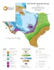
Tectonic Map of Texas | 1997 | University of Texas at Austin, Bureau of Economic Geology | Thematic Maps | Bureau of Economic Geology | |
|
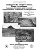
Geology of the Solitario dome, Trans-Pecos Texas: Paleozoic, Mesozoic, and Cenozoic sedimentation, tectonism, and magmatism | 1996 | The Solitario is a circular, 14- to 16-krn-diameter, mid-Tertiary laccolithic dome and caldera in southern Trans-Pecos Texas; it is among the world's largest laccoliths. |
Henry, C.D., Muehlberger, W.R., McCormick, C.L., Smith, C.I., Erdlac, R.J., Davis, L.L., Kunk, M.J. | Report of Investigations | Bureau of Economic Geology |
|
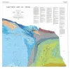
Tectonic map of Texas | 1990 | 4 oversized sheets, Lambert Conformal Conic projection based on standard parallel 33 degrees and 45 degrees. Accompanied by a text booklet, The Tectonic Framework of Texas. |
Ewing, T.E., Budnik, R.T., Ames, J.T., Ridner, D.M., Dillon, R.L. | Thematic Maps | Bureau of Economic Geology |
|
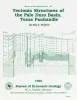
Tectonic structures of the Palo Duro basin, Texas panhandle | 1989 | The Palo Duro Basin is a broad structural low in the southern Texas Panhandle that formed as a result of nearly continuous Pennsylvanian and Permian subsidence. True complexity of this basin is unknown because of the sparsity of structural information. |
Budnik, R.T. | Report of Investigations | Bureau of Economic Geology |
|
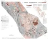
Tectonic map of the Basin and Range Province of Texas and adjacent Mexico | 1985 | Henry, C.D., Price, J.G., Gluck, J.K., Bockoven, N.T. | Miscellaneous Map | Bureau of Economic Geology | |
|
Surficial evidence of tectonic activity and erosion rates, Palestine, Keechi, and Oakwood salt domes, east Texas | 1982 | Surficial geologic investigations at Palestine, Keechi, and Oakwood salt domes have provided information necessary for evaluating these domes as nuclear waste repositories. Diapir growth uplifted sediments to form domes and created complex radial faulting. |
Collins, E.W. | Geological Circular | Bureau of Economic Geology |
|
Regional distribution of fractures in the southern Edwards Plateau and their relationship to tectonics and caves | 1977 | In order to better understand the control exerted by fractures on the recharge and production zones of limestone aquifers, the authors delineated surficial fracture zones in the southern Edwards Plateau, Texas. Lineations were marked on nearly 200 mosaics scale of 1:24,000. |
Wermund, E.G., Cepeda, J.C., Luttrell, P.E. | Geological Circular | Bureau of Economic Geology |