Aquifers Publications
| Title | Publication Year Sort ascending | Abstract | Author | Series | Publisher | |
|---|---|---|---|---|---|---|
|
Hydraulic properties of the Carrizo-Wilcox aquifer in Texas: information for groundwater modeling, planning, and management | 2003 | Use of groundwater-flow models for prediction of future availability of water resources is standard practice. Having accurate hydraulic parameters for input into groundwater-flow models is critical to the generation of realistic local and regional water-resource management plans. |
Mace, R.E., Smyth, R.C. | Report of Investigations | Bureau of Economic Geology |
|
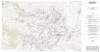
Geologic map of the Seymour aquifer deposits, Vernon, Texas 30x60 minute quadrangle, Texas | 2003 | Collins, E.W. | Open-File Map | Bureau of Economic Geology | |
|
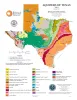
Aquifers of Texas | 2001 | Hovorka, S.D. | Thematic Maps | Bureau of Economic Geology | |
|
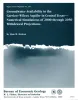
Groundwater availability in the Carrizo-Wilcox aquifer in central Texas -- numerical simulations of 2000 through 2050 withdrawal projections | 1999 | Between 1951 and 1996, groundwater pumpage from the Carrizo-Wilcox aquifer, one of Texas' major aquifer systems, increased in the area between the Colorado and Brazos Rivers from approximately 10,600 to 37,900 acre-ft/yr, primarily as a result of mining needs. |
Dutton, A.R. | Report of Investigations | Bureau of Economic Geology |
|
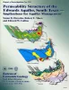
Permeability structure of the Edwards aquifer, south Texas -- implications for aquifer management | 1998 | This report describes the three-dimensional distribution of hydraulic conductivity in the Edwards aquifer from Kinney to Comal Counties, Texas. |
Hovorka, S.D., Mace, R.E., Collins, E.W. | Report of Investigations | Bureau of Economic Geology |
|
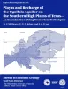
Playas and recharge of the Ogallala aquifer on the southern High Plains of Texas -- an examination using numerical techniques | 1997 | This study used a numerical model to examine the playa-focused recharge theory by comparing it with the spatially uniform approach and with a zonal approach. |
Mullican, W.F., Johns, N.D., Fryar, A.E. | Report of Investigations | Bureau of Economic Geology |
|
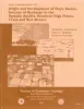
Origin and development of playa basins, sources of recharge to the Ogallala aquifer, southern High Plains, Texas and New Mexico | 1995 | More than 20,000 playa basins have formed on the Southern High Plains of Texas and New Mexico. |
Gustavson, T.C., Holliday, V.T., Hovorka, S.D. | Report of Investigations | Bureau of Economic Geology |
|
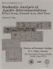
Stochastic analysis of aquifer interconnectedness: Wilcox Group, Trawick area, east Texas | 1989 | Detailed characterization of the spatial distribution of hydraulic conductivity (K) by direct measurement is usually impractical. |
Fogg, G.E. | Report of Investigations | Bureau of Economic Geology |

|
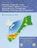
Hydrogeology and hydrochemistry of the Ogallala aquifer, southern High Plains, Texas panhandle and eastern New Mexico | 1988 | The Ogallala aquifer, which underlies the Southern High Plains, consists of the saturated sediments of the Neogene Ogallala Formation. The aquifer is the main source of water for the High Plains of Texas and New Mexico and is being severely depleted by extensive pumpage for irrigation. |
Nativ, Ronit | Report of Investigations | Bureau of Economic Geology |
|
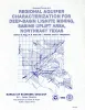
Regional aquifer characterization for deep-basin lignite mining, Sabine uplift area, northeast Texas | 1983 | Lignite deeper than 200 ft (61 m) constitutes about 60 percent of the total lignite resources in Texas. Projections indicate that meeting future demand will require mining this deep-basin lignite. |
Fogg, G.E., Kaiser, W.R., Ambrose, M.L., Macpherson, G.L. | Geological Circular | Bureau of Economic Geology |