Publication Search

Geologic Maps Publications

Title Publication Year Sort ascending Abstract Author Series Publisher
Geologic map of the New Braunfels West quadrangle, Texas Geologic map of the New Braunfels West quadrangle, Texas 1993 Collins, E.W. Open-File Map Bureau of Economic Geology
Geologic map of the New Braunfels East quadrangle, Texas Geologic map of the New Braunfels East quadrangle, Texas 1993 Collins, E.W. Open-File Map Bureau of Economic Geology
Geologic map of the Fischer quadrangle, Texas Geologic map of the Fischer quadrangle, Texas 1992 Collins, E.W. Open-File Map Bureau of Economic Geology
Geologic map of the Anhalt quadrangle, Texas Geologic map of the Anhalt quadrangle, Texas 1992 Collins, E.W. Open-File Map Bureau of Economic Geology
Geologic map of the Smithson Valley quadrangle, Texas Geologic map of the Smithson Valley quadrangle, Texas 1992 Collins, E.W. Open-File Map Bureau of Economic Geology
Geologic map of Texas Geologic map of Texas 1992

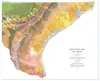
This large, 4-sheet geologic map displays more than 350 lithostratigraphic units ranging in age from Precambrian to Quaternary.

University of Texas at Austin, Bureau of Economic Geology, Barnes, V.E., Hartmann, B., Scranton, D.F. Thematic Maps Bureau of Economic Geology
Geologic map of the Spring Branch Quadrangle, Texas Geologic map of the Spring Branch Quadrangle, Texas 1992 Collins, E.W. Open-File Map Bureau of Economic Geology
Geologic map of the Devil's Backbone Quadrangle, Texas Geologic map of the Devil's Backbone Quadrangle, Texas 1991 Collins, E.W. Open-File Map Bureau of Economic Geology
Geologic map of the Wimberley Quadrangle, Texas Geologic map of the Wimberley Quadrangle, Texas 1991 Collins, E.W., Baumgardner, R.W., Jr., Raney, J.A. Open-File Map Bureau of Economic Geology
Geologic map of the Hunter Quadrangle, Texas Geologic map of the Hunter Quadrangle, Texas 1991 Baumgardner, R.W., Jr., Collins, E.W. Open-File Map Bureau of Economic Geology