Bureau of Economic Geology Publications
| Title | Publication Year Sort ascending | Abstract | Author | Publisher | |
|---|---|---|---|---|---|
|
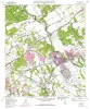
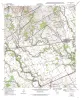
Geologic map of the Schertz quadrangle, Texas | 1993 | Collins, E.W. | Bureau of Economic Geology | |
|
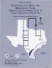
Geothermal and heavy-oil resources in Texas: direct use of geothermal fluids to enhance recovery of heavy oil | 1993 | In a five-county area of South Texas, geopressured-geothermal reservoirs in the Paleocene-Eocene Wilcox Group lie below medium- to heavy-oil reservoirs in the Eocene Jackson Group. This fortuitous association suggests the use of geothermal fluids for thermally enhanced oil recovery (TEOR). |
Seni, S.J., Walter, T.G. | Bureau of Economic Geology |
|
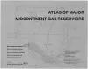
Atlas of Major Midcontinent Gas Reservoirs | 1993 | Bebout, D.G., White, W.A., Hentz, T.F., Grasmick, M.K. | Bureau of Economic Geology | |
|
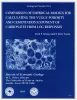
Comparison of Empirical Models for Calculating the Vuggy Porosity and Cementation Component of Carbonates from Log... | 1993 | Formation evaluation in heterogeneous carbonate reservoirs is complicated by the presence of multiple pore types. Acoustic properties, Archie cementation exponents, and permeability transforms differ according to pore type. |
Wang, F.P., Lucia, F.J. | Bureau of Economic Geology |
|
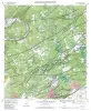
Geologic map of the Bat Cave quadrangle, Texas | 1993 | Collins, E.W. | Bureau of Economic Geology | |
|
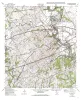
Geologic map of the Marion Quadrangle, Texas | 1993 | Collins, E.W. | Bureau of Economic Geology | |
|
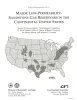
Major low-permeability-sandstone gas reservoirs in the continental United States | 1993 | This report summarizes geologic, engineering, and production information on 24 low-permeability, gas-bearing sandstone reservoirs in 13 basins in the United States. |
Dutton, S.P., Clift, S.J., Hamilton, D.S., Hamlin, H.S., Hentz, T.F., Howard, W.E., Akhter, M.S., Laubach, S.E. | Bureau of Economic Geology |
|
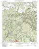
Geologic map of the Bulverde quadrangle, Texas | 1993 | Collins, E.W. | Bureau of Economic Geology | |
|
Geologic map of the McQueeney Quadrangle, Texas | 1993 | Collins, E.W. | Bureau of Economic Geology | |

|
Geologic map of the New Braunfels West quadrangle, Texas | 1993 | Collins, E.W. | Bureau of Economic Geology |