Bureau of Economic Geology Publications
| Title | Publication Year Sort ascending | Abstract | Author | Publisher | |
|---|---|---|---|---|---|
|
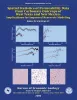
Spatial Statistics of Permeability Data from Carbonate Outcrops of West Texas and New Mexico: Implications for Improved Reservoir Modeling | 2000 | This report presents a statistical analysis of outcrop-permeability data for quantifying spatial patterns of petrophysical heterogeneity in carbonates that are difficult or impossible to observe in the subsurface. |
Jennings, J.W., Jr. | Bureau of Economic Geology |
|
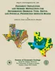
Pavement Deflection and Seismic Refraction for Determining Bedrock Type, Depth, and Physical Properties beneath Roads | 2000 | We examined the relationship between three data types--geologic maps, measurements of pavement deflection under load, and seismic refraction data-- from diverse geologic settings in Texas to determine (1) whether geologic maps and seismic refraction data might be used to interpret deflections and |
Paine, J.G., Murphy, M.R. | Bureau of Economic Geology |
|
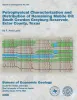
Petrophysical characterization and distribution of remaining mobile oil: South Cowden Grayburg Reservoir, Ector County, Texas | 2000 | This report uses the rock fabric method to construct a reservoir model of a Permian Basin Grayburg dolomite reservoir. Rock fabrics are related to porosity, permeability, and capillary pressure and are distributed within a sequence stratigraphic framework. |
Lucia, F.J. | Bureau of Economic Geology |
|
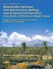
Relationship between arid geomorphic settings and unsaturated zone flow: case study, Chihuahuan desert, Texas | 2000 | Because geomorphic features can readily be mapped, our ability to characterize unsaturated flow over large areas would be greatly enhanced if relationships between geomorphic settings and unsaturated flow could be identified. |
Scanlon, B.R., Goldsmith, R.S., Langford, R.P. | Bureau of Economic Geology |
|
Regional stratigraphic cross sections, Comanche Cretaceous (Fredericksburg - Washita Division), Edwards and Stockton plateaus, West Texas: interpretation of sedimentary facies, depositional cycles, and tectonics | 2000 | Six interlocking regional stratigraphic cross sections of Lower Cretaceous strata (middle Albian-lower Cenomanian) of the Edwards and Stockton Plateaus of West Texas illustrate the vertical and lateral extent of lithostratigraphic units and distribution of facies and facies tracts. |
Smith, C.I., Brown, J.B., Lozo, F.E. | Bureau of Economic Geology |
|
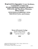
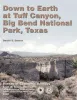
Down to earth at Tuff Canyon, Big Bend National Park, Texas | 2000 | Written for a nontechnical audience, this guide describes the Tuff Canyon area in detail and includes a glossary of terms that might be unfamiliar to non-geologists. Color photographs and sketches depict the geologic features, fauna, and flora of this part of Big Bend National Park. |
Barker, D.S. | Bureau of Economic Geology |
|
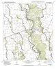
Geologic map of the Blanco Lake quadrangle, Texas | 2000 | Collins, E.W. | Bureau of Economic Geology | |
|
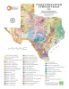
Vegetation/Cover Types of Texas | 2000 | Frye, R.G., Brown, K.L., McMahan, C.A. | Bureau of Economic Geology | |
|
Geologic map of the Bastrop quadrangle, Texas | 2000 | Collins, E.W. | Bureau of Economic Geology | |
|
Geologic map of the Bastrop SW quadrangle, Texas | 2000 | Collins, E.W. | Bureau of Economic Geology |