Breadcrumb
Bureau of Economic Geology Publications
| Title | Publication Year Sort ascending | Abstract | Author | Publisher | |
|---|---|---|---|---|---|
| |
Geologic map of the Cypress Creek quadrangle, Texas | 2002 | Collins, E.W. | Bureau of Economic Geology | |
| |
Petrography and diagenesis of a half-billion-year-old cratonic sandstone (Hickory), Llano region, Texas | 2002 | We studied the Hickory Sandstone Member of the Riley Formation, Central Texas, to assess the diagenetic history of a cratonic sandstone, which, in spite of its great age, remains porous and permeable where it has not been buried more than 1 km. |
McBride, E.F., Abdel-Wahab, A.A., Milliken, K.L. | Bureau of Economic Geology |
| |
Geologic map of the Driftwood quadrangle, Texas | 2002 | Collins, E.W. | Bureau of Economic Geology | |
| |
Seismic Sedimentology by Stratal Slicing--A Case History in the Mioceno Norte Area, Lake Maracaibo, Venezuela | 2002 | This report describes a case history in a densely drilled, but spatially restricted, area (47 km2) containing 240 wells in the Mioceno Norte Area of Lake Maracaibo, Venezuela. |
Zeng, Hongliu, Ambrose, W.A., Villalta, Edgar, Tyler, Roger | Bureau of Economic Geology |
| |
Down to earth at Big Bend Ranch State Park, Texas: geologic map and trail-side geology | 2002 | This full-color, oversize map, designed for hikers in the park, describes geologic units and features. The text documents the geologic history of the Big Bend Ranch State Park area. Support was provided by the Texas Parks and Wildlife Department and the U.S. Geological Survey. |
Henry, C.D., Raney, J.A. | Bureau of Economic Geology |
| |
Geologic map of the Crabapple Creek quadrangle, Texas | 2002 | Collins, E.W. | Bureau of Economic Geology | |
| |
Geologic map of the Dripping Springs quadrangle, Texas | 2002 | Collins, E.W. | Bureau of Economic Geology | |
| |
Geological controls on reservoir development in a Leonardian (Lower Permian) carbonate platform reservoir, Monahans field, West Texas | 2002 | 
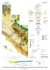
This report combines borehole core and geophysical log study with porosity and permeability data to define patterns of facies and permeability distribution in a typical upper Clear Fork reservoir in the Permian Basin. |
Ruppel, S.C. | Bureau of Economic Geology |
| |
Down to Earth at Mustang Island, Texas | 2002 | Beautifully illustrated by more than 100 photos and diagrams, this nontechnical guide surveys the geologic evolution of Mustang Island and the relationship between physical setting and biologic environments along the Texas coast. |
Raney, J.A., White, W.A. | Bureau of Economic Geology |
| |
Geologic map of the Rafter Hollow quadrangle, Texas | 2002 | Collins, E.W. | Bureau of Economic Geology |