Bureau of Economic Geology Publications
| Title | Publication Year Sort ascending | Abstract | Author | Publisher | |
|---|---|---|---|---|---|
|
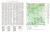
Geologic map of the Cain City quadrangle, Gillespie and Kendall Counties, Texas | 1952 | Cain City quadrangle is south of the Llano region and is in the marginal portion of the Edwards Plateau where much of the plateau surface has been destroyed by erosion. Northeastward-trending lobes and outliers of the Edwards Plateau are present in the southern part. |
Barnes, V.E. | Bureau of Economic Geology |
|
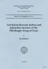
Correlation between surface and subsurface sections of the Ellenberger Group of Texas | 1952 | The Ellenburger of Texas was first defined as a marine limestone formation of Cambrian and Ordovician age (Paige, 1912), but recently it has been subdivided into several formations and the term Ellenburger given group status (Cloud and Barnes, 1948). |
Hendricks, Leo | Bureau of Economic Geology |
|
Geologic map of the Stonewall quadrangle, Gillespie and Kendall Counties, Texas | 1952 | Stonewall quadrangle is south of the Llano region and is in the marginal portion of the Edwards Plateau where much of the plateau surface has been destroyed by erosion. |
Barnes, V.E. | Bureau of Economic Geology |
|
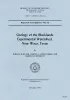
Geology of the Blacklands Experimental Watershed, near Waco, Texas | 1952 | The Blacklands Experimental Watershed, a hydrologic research project of the Soil Conservation Service located about 15 miles southeast of Waco, Texas, is underlain by marls and chalks belonging to the Taylor group of the Gulf series of the Cretaceous system, which, in conformity with the general |
Lonsdale, J.T. | Bureau of Economic Geology |
|
Boundary of the Pennsylvanian and Permian(?) in the subsurface Scurry reef, Scurry County, Texas | 1952 | Heck, W.A., Yenne, K.A., Henbest, L.G. | Bureau of Economic Geology | |
|
Recognition of Hipparions and other horses in the middle Miocene Mammalian faunas of the Texas Gulf region | 1952 | New information concerning the ancestry of the later Tertiary horses, Calippus, Protohippus (in the original sense), Hipparion, Neohipparion, and Nannippus, has been obtained from a restudy of the various mammalian farmas of the Coastal Plain in Texas, based in the main on the extensive collectio |
Quinn, J.H. | Bureau of Economic Geology |
|
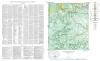
Geologic map of the Squaw Creek Quadrangle, Gillespie and Mason Counties, Texas | 1952 | The Squaw Creek quadrangle is partly within the Llano region and partly within the Edwards Plateau province. |
Barnes, V.E. | Bureau of Economic Geology |
|
Agua Fria quadrangle, Brewster County, Texas | 1951 | Moon, C.G. | Bureau of Economic Geology | |
|
Pegmatites of the Van Horn Mountains, Texas | 1951 | Zoned and unzoned perthite-quartz-plagioclase-muscovite pegmatites in the form of tabular bodies, irregular bodies with tabular branches, irregular masses, elongate lenses, lit-par-lit zones, and small augen and stringers are distributed throughout the Precambrian metasedimentary rocks of the Mic |
Flawn, P.T. | Bureau of Economic Geology |
|
Buried Hill at Wilcox-Carrizo Contact in East Texas | 1951 | A recently discovered buried hill, at least 77 feet high, is composed of strata of the Wilcox group (lower Eocene) and covered on its flanks by cross-bedded sands of the lower Carrizo and at the top by level-bedded shales and silts of the upper Carrizo formation. |
Stenzel, H.B. | Bureau of Economic Geology |