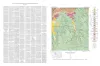
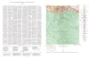
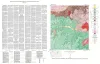
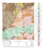
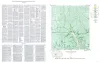
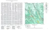
The Squaw Creek quadrangle is partly within the Llano region and partly within the Edwards Plateau province.
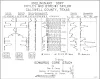
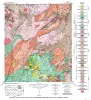
The Hazel mine is one of the oldest mines in Texas and has been the largest copper-producing property in the State.
Chemical analyses show that a reef approximately 100 feet thick in the lower portionof the Marble Falls limestone near Marble Falls, Burnet County, Texas, is exceptionally pure.