|
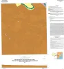
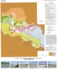
Geologic map of the Guadalupe delta, Texas Gulf of Mexico Coast: Sheet 5-Tivoli quadrangle |
Collins, E.W., Paine, J.G. |
2013 |
Open-File Map |
|
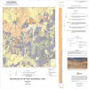
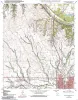
Geologic map of the Poteet quadrangle, Texas |
Elliott, Brent A. |
2013 |
Open-File Map |
|
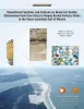
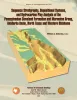
Depositional Systems and Controls on Reservoir Quality (Determined from Core Data) in Deeply Buried Tertiary Strata in the Texas-Louisiana Gulf of Mexico |
Ambrose, W.A., Loucks, R.G., Dutton, S.P. |
2013 |
Report of Investigations |
|
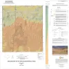
Geologic map of the Thelma quadrangle, Texas |
Elliott, Brent A. |
2013 |
Open-File Map |
|
GCAGS Transactions Volume 63 (2013) New Orleans |
|
2013 |
Gulf Coast Association of Geological Societies |
|
Annual Report of the Bureau of Economic Geology 2013 |
University of Texas at Austin, Bureau of Economic Geology |
2013 |
Annual Reports |
|
GCAGS Journal, Volume 2 (2013) |
|
2013 |
Gulf Coast Association of Geological Societies |
|
Wolfberry (Wolfcampian-Leonardian) Deep-Water Depositional Systems in the Midland Basin: Stratigraphy, Lithofacies, Reservoirs, and Source Rocks |
Hamlin, H.S., Baumgardner, R.W., Jr. |
2012 |
Report of Investigations |
|
New Understanding of the Petroleum Systems of Continental Margins of the World |
|
2012 |
Gulf Coast Section SEPM |
|
GCAGS Transactions Volume 62 (2002) Austin |
|
2012 |
Gulf Coast Association of Geological Societies |
|
Annual Report of the Bureau of Economic Geology 2012 |
University of Texas at Austin, Bureau of Economic Geology |
2012 |
Annual Reports |
|
GCAGS Journal, Volume 1 (2012) |
|
2012 |
Gulf Coast Association of Geological Societies |
|
Geologic map of the Nueces Delta-Annaville and Odem quadrangles, Texas Gulf Coast |
Paine, J.G., Collins, E.W. |
2012 |
Open-File Map |
|
Geologic map of the Gainesville North quadrangle, Texas |
Collins, E.W. |
2012 |
Open-File Map |
|
Sequence Stratigraphy, Depositional Systems, and Hydrocarbon Play Analysis of the Pennsylvanian Cleveland Formation and Marmaton Group, Anadarko Basin, North Texas and Western Oklahoma |
Ambrose, W.A. |
2011 |
Report of Investigations |
|
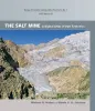
The Salt Mine: A Digital Atlas of Salt Tectonics |
Hudec, M.R., Jackson, M.P.A. |
2011 |
Udden Series |
|
Attributes: New Views on Seismic |
|
2011 |
Gulf Coast Section SEPM |
|
Geology and Geomorphology of the Enchanted Rock State Natural Area, Central Texas |
Reed, Robert M. |
2011 |
Austin Geological Society |
|
GCAGS Transactions Volume 61 (2001), Veracruz, Mexico |
|
2011 |
Gulf Coast Association of Geological Societies |
|
Geologic Maps of the Upper Cretaceous and Tertiary Strata, Big Bend National Park, Texas |
Cooper, R.W. |
2011 |
Miscellaneous Map |