|
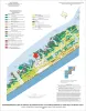
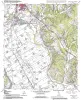
Geo-Environmental map of Central Galveston Island, Lake Como quadrangle, Texas |
Tremblay, T.A., Gibeaut, J.C., Waldinger, R.L., White, W.A., Collins, E.W. |
2006 |
Open-File Map |
|
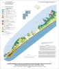
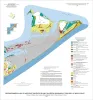
Geo-Environmental map of Southwest Galveston Island, San Luis Pass and Sea Isle quadrangles, Texas Gulf of Mexico |
Tremblay, T.A., Gibeaut, J.C., Waldinger, R.L., White, W.A., Collins, E.W. |
2006 |
Open-File Map |
|
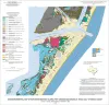
Geo-Environmental map of Northern Mustang Island, Port Aransas quadrangle, Texas Gulf of Mexico Coast |
Tremblay, T.A., Gibeaut, J.C., Waldinger, R.L., White, W.A., Collins, E.W. |
2006 |
Open-File Map |
|
Volcanic Features of the Austin Area, Texas |
Caran, S.C., Housh, Todd, Cherepon, Alan J. |
2006 |
Austin Geological Society |
|
Geo-Environmental map of Southern Mustang Island, Crane Islands NW quadrangle, Texas Gulf of Mexico Coast |
Tremblay, T.A., Gibeaut, J.C., Waldinger, R.L., White, W.A., Collins, E.W. |
2006 |
Open-File Map |
|
GCAGS Transactions Volume 56 (2006) Lafayette |
|
2006 |
Gulf Coast Association of Geological Societies |
|
Annual Report of the Bureau of Economic Geology 2006 |
University of Texas at Austin, Bureau of Economic Geology |
2006 |
Annual Reports |
|
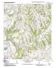
Geologic map of the Baileyville quadrangle, Texas |
Collins, E.W. |
2006 |
Open-File Map |
|
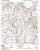
Geologic map of the Hammond quadrangle, Texas |
Collins, E.W. |
2006 |
Open-File Map |
|
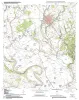
Geologic map of the Maysfield quadrangle, Texas |
Collins, E.W. |
2006 |
Open-File Map |
|
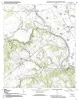
Geologic map of the Calvert quadrangle, Texas |
Collins, E.W. |
2006 |
Open-File Map |
|
Geologic map of the Gause quadrangle, Texas |
Collins, E.W. |
2006 |
Open-File Map |
|
Geologic map of the Hearne South quadrangle, Texas |
Collins, E.W. |
2006 |
Open-File Map |
|
Geo-Environmental map of Northeast Galveston Island, Galveston quadrangle, Texas |
Tremblay, T.A., Gibeaut, J.C., Waldinger, R.L., White, W.A., Collins, E.W. |
2006 |
Open-File Map |
|
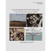
Petrographic Characterization of the Barnett Shale, Fort Worth Basin, Texas: Thesis and Appendices |
Papazis, P.K. |
2005 |
Seminars and Workshops |

|
GCAGS Transactions Volume 55 (2005) New Orleans |
|
2005 |
Gulf Coast Association of Geological Societies |
|
Petroleum reserves |
|
2005 |
Houston Geological Society |
|
Annual Report of the Bureau of Economic Geology 2005 |
University of Texas at Austin, Bureau of Economic Geology |
2005 |
Annual Reports |
|
Play Analysis and Digital Portfolio of Major Oil Reservoirs in the Permian Basin |
Dutton, S.P., Broadhead, R.F., Breton, C.L., Raatz, W.D., Ruppel, S.C., Kerans, Charles |
2005 |
Report of Investigations |
|
Africa: Path to Discovery |
|
2005 |
Houston Geological Society |