|
Annual Report of the Bureau of Economic Geology 2009 |
University of Texas at Austin, Bureau of Economic Geology |
2009 |
Annual Reports |
|
Supplement to Guidebook 14 |
Brown, L.F., Jr., Ambrose, W.A., Carr, D.L. |
2009 |
Guidebook |
|
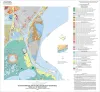
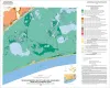
Geoenvironmental map of Big Hill Bayou quadrangle, Texas, Gulf of Mexico Coast |
Tremblay, T.A., Caudle, T.L., White, W.A. |
2009 |
Open-File Map |
|
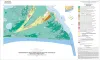
Geoenvironmental map of Port Arthur South quadrangle, Texas, Gulf of Mexico Coast |
Tremblay, T.A., Caudle, T.L., White, W.A. |
2009 |
Open-File Map |
|
Geoenvironmental map of Clam Lake quadrangle, Texas, Gulf of Mexico Coast |
Tremblay, T.A., White, W.A., Caudle, T.L. |
2009 |
Open-File Map |
|
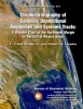
Chronostratigraphy of Cenozoic Depositional Sequences and Systems Tracts: A Wheeler Chart of the Northwest Margin of the Gulf of Mexico Basin |
Brown, L.F., Jr., Loucks, R.G. |
2009 |
Report of Investigations |
|
Geoenvironmental map of Sabine Pass and Texas Point quadrangles, Texas, Gulf of Mexico Coast |
Tremblay, T.A., White, W.A., Caudle, T.L. |
2009 |
Open-File Map |
|
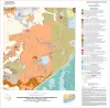
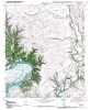
Geologic map of the Blum quadrangle, Texas |
Collins, E.W. |
2009 |
Open-File Map |
|
Submarine Mass Movements and Their Consequences. 4th International Symposium |
Mosher, D.C., Shipp, R.C., Moscardelli, Lorena, Chaytor, J.D., Baxter, C.D.P., Lee, H.J., Urgeles, Roger |
2009 |
Selected Reports |
|
Earth's Art, Celebrating the Centennial of the Bureau of Economic Geology 1909-2009 |
Laubach, S.E., Tinker, S.W. |
2009 |
Udden Series |
|
Geologic Map of the Covington quadrangle, Texas |
Collins, E.W. |
2009 |
Open-File Map |
|
Geologic Map of the Files Valley quadrangle, Texas |
Collins, E.W. |
2009 |
Open-File Map |
|
Geologic map of the Itasca quadrangle, Texas |
Collins, E.W. |
2009 |
Open-File Map |
|
Sequence Stratigraphy, Depositional Systems, and Production Trends in the Atoka Series and Mid-Pennsylvanian Cleveland and Marmaton Formations, Western Anadarko Basin |
Carr, David, Hentz, T.F., Ambrose, W.A., Potter, E.C., Clift, S.J. |
2009 |
Seminars and Workshops |
|
GCAGS Transactions Volume 59 (2009) Shreveport |
|
2009 |
Gulf Coast Association of Geological Societies |
|
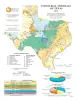
Industrial Minerals of Texas |
Kyle, J.R. |
2008 |
Thematic Maps |
|
Annual Report of the Bureau of Economic Geology 2008 |
University of Texas at Austin, Bureau of Economic Geology |
2008 |
Annual Reports |
|
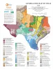
General Soil Map of Texas |
University of Texas at Austin, Bureau of Economic Geology |
2008 |
Thematic Maps |
|
Africa: Opportunity from Coast to Coast |
|
2008 |
Houston Geological Society |
|
Leaning Forward, A Memoir |
Fisher, W.L. |
2008 |
Udden Series |