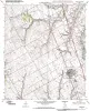
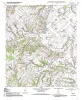
|
Geologic map of the Itasca quadrangle, Texas |
2009 |
|
Collins, E.W. |
Open-File Map |
Bureau of Economic Geology |
|
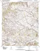
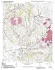
Geologic map of the Morgan quadrangle, Texas |
2009 |
|
Collins, E.W. |
Open-File Map |
Bureau of Economic Geology |
|
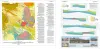
Geologic map of the Glenn Spring quadrangle, Big Bend National Park, Texas |
2008 |
|
Collins, E.W., Muehlberger, W.R., Dickerson, P.W. |
Miscellaneous Map |
Bureau of Economic Geology |
|
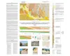
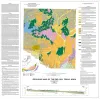
Geologic map of the Southeast Part of the Austin, Texas, 30x60 Minute Quadrangle; Central Texas Population Corridor Encompassing Bastrop and Smithville |
2008 |
|
Collins, E.W. |
Miscellaneous Map |
Bureau of Economic Geology |
|
Geologic map of the Tunis quadrangle, Texas |
2007 |
|
Collins, E.W. |
Open-File Map |
Bureau of Economic Geology |
|
Geologic map of the Bryan West quadrangle, Texas |
2007 |
|
Collins, E.W. |
Open-File Map |
Bureau of Economic Geology |
|
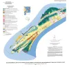
Geoenvironmental map of southwest Bolivar Peninsula, Bolivar and Flake quadrangles, Texas Gulf of Mexico Coast |
2007 |
|
Tremblay, T.A., White, W.A., Waldinger, R.L., Collins, E.W. |
Open-File Map |
Bureau of Economic Geology |
|
Geologic map of the Del Rio, Texas, area |
2007 |
|
Collins, E.W. |
Miscellaneous Map |
Bureau of Economic Geology |
|
Geologic map of the Chances Store quadrangle, Texas |
2007 |
|
Collins, E.W. |
Open-File Map |
Bureau of Economic Geology |
|
Reimers Ranch and Westcave Preserve, Landscapes, Water, and Lower Cretaceous Stratigraphy of the Pedernales Watershed, Western Travis County, Texas |
2007 |
|
Hunt, B.B., Woodruff, C.M., Jr., Collins, E.W. |
Austin Geological Society |
Austin Geological Society |