|
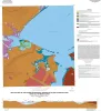
Geologic map of the Bayside quadrangle: Aransas Delta and Copano Bay Area, Texas Gulf of Mexico Coast |
2014 |
|
Paine, J.G., Collins, E.W. |
Open-File Map |
Bureau of Economic Geology |
|
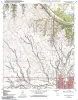
Geologic map the Muenster East quadrangle, Texas |
2013 |
|
Collins, E.W. |
Open-File Map |
Bureau of Economic Geology |
|
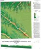
Geologic map of the Guadalupe delta, Texas Gulf of Mexico Coast: Sheet 1-Austwell quadrangle |
2013 |
|
Paine, J.G., Collins, E.W. |
Open-File Map |
Bureau of Economic Geology |
|
Geologic map of the Guadalupe delta, Texas Gulf of Mexico Coast: Sheet 2-Bloomington SW quadrangle |
2013 |
|
Collins, E.W., Paine, J.G. |
Open-File Map |
Bureau of Economic Geology |
|
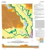
Geologic map of the Guadalupe delta, Texas Gulf of Mexico Coast: Sheet 3-Green Lake quadrangle |
2013 |
|
Paine, J.G., Collins, E.W. |
Open-File Map |
Bureau of Economic Geology |
|
Geologic map of the Guadalupe delta, Texas Gulf of Mexico Coast: Sheet 4-Sea Drift quadrangle |
2013 |
|
Collins, E.W., Paine, J.G. |
Open-File Map |
Bureau of Economic Geology |
|
Geologic map of the Guadalupe delta, Texas Gulf of Mexico Coast: Sheet 5-Tivoli quadrangle |
2013 |
|
Collins, E.W., Paine, J.G. |
Open-File Map |
Bureau of Economic Geology |
|
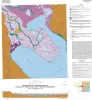
Geologic map of the Nueces Delta-Annaville and Odem quadrangles, Texas Gulf Coast |
2012 |
|
Paine, J.G., Collins, E.W. |
Open-File Map |
Bureau of Economic Geology |
|
Geologic map of the Gainesville North quadrangle, Texas |
2012 |
|
Collins, E.W. |
Open-File Map |
Bureau of Economic Geology |
|
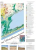
Geoenvironmental map of Matagorda - Matagorda SW quadrangles, Texas Gulf of Mexico Coast |
2011 |
|
Tremblay, T.A., Collins, E.W., Paine, J.G. |
Open-File Map |
Bureau of Economic Geology |