|
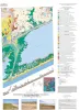
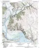
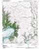
Geoenvironmental map of Matagorda - Matagorda SW quadrangles, Texas Gulf of Mexico Coast |
2011 |
|
Tremblay, T.A., Collins, E.W., Paine, J.G. |
Open-File Map |
Bureau of Economic Geology |
|
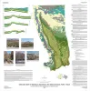
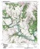
Geologic map of Mariscal Mountain, Big Bend National Park, Texas |
2010 |
|
Dickerson, P.W., Muehlberger, W.R., Collins, E.W. |
Miscellaneous Map |
Bureau of Economic Geology |
|
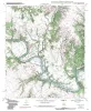
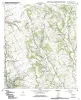
Geologic map of the Brazos Point quadrangle, Texas |
2010 |
|
Collins, E.W. |
Open-File Map |
Bureau of Economic Geology |
|
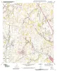
Geologic map of the Lakeside Village quadrangle, Texas |
2010 |
|
Collins, E.W. |
Open-File Map |
Bureau of Economic Geology |
|
Geologic map of the Blanton quadrangle, Texas |
2010 |
|
Collins, E.W. |
Open-File Map |
Bureau of Economic Geology |
|
Geologic map of the Hillsboro West quadrangle, Texas |
2010 |
|
Collins, E.W. |
Open-File Map |
Bureau of Economic Geology |
|
Geologic map of the Keene quadrangle, Texas |
2010 |
|
Collins, E.W. |
Open-File Map |
Bureau of Economic Geology |
|
Geologic map of the Blum quadrangle, Texas |
2009 |
|
Collins, E.W. |
Open-File Map |
Bureau of Economic Geology |
|
Geologic Map of the Covington quadrangle, Texas |
2009 |
|
Collins, E.W. |
Open-File Map |
Bureau of Economic Geology |
|
Geologic Map of the Files Valley quadrangle, Texas |
2009 |
|
Collins, E.W. |
Open-File Map |
Bureau of Economic Geology |