|
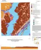
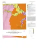
Geologic map of the Saint Charles Bay quadrangle, Texas Gulf of Mexico coast |
2016 |
|
Paine, J.G., Collins, E.W. |
Open-File Map |
Bureau of Economic Geology |
|
Geologic map of the Bee Cave quadrangle, Texas |
2016 |
|
Collins, E.W. |
Open-File Map |
Bureau of Economic Geology |
|
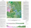
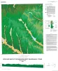
Geologic map of the upper Lake Travis area, Texas |
2016 |
|
Woodruff, C.M., Jr., Collins, E.W. |
Miscellaneous Map |
Bureau of Economic Geology |
|
Geologic map of the Gainesville South quadrangle, Texas |
2015 |
|
Collins, E.W. |
Open-File Map |
Bureau of Economic Geology |
|
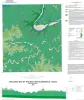
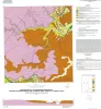
Geologic map of the Rincon Bend quadrangle, Aransas River and Copano Bay area, Texas Gulf of Mexico coast |
2015 |
|
Paine, J.G., Collins, E.W., Costard, L. |
Open-File Map |
Bureau of Economic Geology |
|
Geologic map of the Woodsboro quadrangle: Aransas and Mission Rivers, and Copano Bay area, Texas Gulf of Mexico Coast |
2015 |
|
Paine, J.G., Collins, E.W., Costard, L. |
Open-File Map |
Bureau of Economic Geology |
|
Geologic map of the Muenster West quadrangle, Texas |
2015 |
|
Collins, E.W. |
Open-File Map |
Bureau of Economic Geology |
|
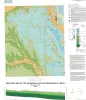
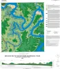
Geologic map of the Pace Bend quadrangle, Texas |
2015 |
|
Woodruff, C.M., Jr., Collins, E.W. |
Open-File Map |
Bureau of Economic Geology |
|
Geologic map of the Hood quadrangle |
2014 |
|
Collins, E.W. |
Open-File Map |
Bureau of Economic Geology |
|
Geologic map of the Bayside quadrangle: Aransas Delta and Copano Bay Area, Texas Gulf of Mexico Coast |
2014 |
|
Paine, J.G., Collins, E.W. |
Open-File Map |
Bureau of Economic Geology |