|
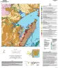
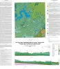
Geologic map of the Copano Bay area, Texas Gulf Coast |
2025 |
|
Paine, J.G., Collins, E.W., Costard, L., Grunau, B.A., Morris, J.N., Caudle, T.L. |
Open-File Map |
Bureau of Economic Geology |
|
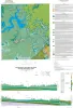
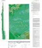
Geologic map of the lower Lake Travis and Lake Austin vicinity, Texas |
2019 |
|
Woodruff, C.M., Jr., Collins, E.W. |
Miscellaneous Map |
Bureau of Economic Geology |
|
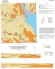
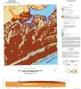
Geologic map of the Kamey quadrangle, Texas Gulf of Mexico Coast |
2018 |
|
Paine, J.G., Collins, E.W., Costard, L. |
Open-File Map |
Bureau of Economic Geology |
|
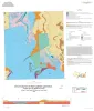
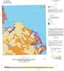
Geologic map of the Point Comfort quadrangle, Texas Gulf of Mexico Coast |
2018 |
|
Paine, J.G., Collins, E.W., Costard, L. |
Open-File Map |
Bureau of Economic Geology |
|
Geologic map of Mansfield Dam, Jollyville, Austin West, and Bee Cave quadrangles, Central Texas (Lower Lake Travis and Lake Austin vicinity) |
2018 |
|
Woodruff, C.M., Jr., Collins, E.W. |
Open-File Map |
Bureau of Economic Geology |
|
Geologic Map of the Shingle Hills-Dripping Springs-Driftwood-Rough Hollow-Henly-Hammetts Crossing Area, Central Texas |
2017 |
|
Collins, E.W. |
Open-File Map |
Bureau of Economic Geology |
|
Geologic Map of the Seadrift NE Quadrangle, Texas Gulf of Mexico Coast |
2017 |
|
Paine, J.G., Collins, E.W. |
Open-File Map |
Bureau of Economic Geology |
|
Geologic Map of the Port Lavaca East Quadrangle, Texas Gulf of Mexico Coast |
2017 |
|
Paine, J.G., Collins, E.W. |
Open-File Map |
Bureau of Economic Geology |
|
Canyon Dam Spillway Gorge and Natural Bridge Caverns: Geologic Excursions in the Balcones Fault Zone, Central Texas |
2017 |
|
Woodruff, C.M., Jr., Collins, E.W., Potter, E.C., Loucks, R.G. |
Guidebook |
Bureau of Economic Geology |
|
Geologic map of Port O'Connor quadrangle, Texas Gulf of Mexico coast |
2016 |
|
Paine, J.G., Collins, E.W. |
Open-File Map |
Bureau of Economic Geology |