Publication Year
2002
Publisher
Series
Down To Earth
Abstract
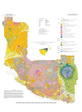
This full-color, oversize map, designed for hikers in the park, describes geologic units and features. The text documents the geologic history of the Big Bend Ranch State Park area. Support was provided by the Texas Parks and Wildlife Department and the U.S. Geological Survey.

Publication Year
2002
Publisher
Series
Down To Earth
Abstract
Beautifully illustrated by more than 100 photos and diagrams, this nontechnical guide surveys the geologic evolution of Mustang Island and the relationship between physical setting and biologic environments along the Texas coast. Support was provided by the National Oceanic and Atmospheric Administration under the Texas Coastal Management Program, administered by the Texas General Land Office, and by the Texas Parks and Wildlife Department.
Publication Year
2001
Publisher
Series
Texas Memorial Museum
Publication Year
2001
Series
Gulf Coast Association of Geological Societies
Publication Year
2001
Publisher
Series
Austin Geological Society