Edwards Aquifer Publications
| Title | Publication Year Sort ascending | Abstract | Author | Series | Publisher | |
|---|---|---|---|---|---|---|
|
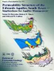
Permeability structure of the Edwards aquifer, south Texas -- implications for aquifer management | 1998 | This report describes the three-dimensional distribution of hydraulic conductivity in the Edwards aquifer from Kinney to Comal Counties, Texas. |
Hovorka, S.D., Mace, R.E., Collins, E.W. | Report of Investigations | Bureau of Economic Geology |
|
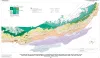
Structure Map of the San Antonio Segment of the Edwards Aquifer and Balcones Fault Zone, South-Central Texas: Structural Framework of a Major Limestone Aquifer: Kinney, Uvalde, Medina, Bexar, Comal, and Hays Counties | 1997 | Collins, E.W., Hovorka, S.D. | Miscellaneous Map | Bureau of Economic Geology | |
|
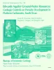
Edwards aquifer ground-water resources: geologic controls on porosity development in platform carbonates, south Texas | 1996 | Focusing on the highly developed Edwards aquifer, which supplies water for a large area of south-central Texas, this report presents a three-dimensional model of the porosity distribution in the aquifer, which quantifies the spatial distribution of water resources and provides information that ca |
Hovorka, S.D., Dutton, A.R., Ruppel, S.C., Yeh, J.S. | Report of Investigations | Bureau of Economic Geology |
|
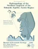
Hydrogeology of the northern segment of the Edwards aquifer, Austin region | 1990 | Geologic mapping and fracture analysis of the Lower Cretaceous Edwards aquifer strata near Georgetown and Round Rock, Texas, were performed to provide a better understanding of the geologic framework of the Balcones Fault Zone and to provide information for assessing ground-water flow characteris |
Senger, R.K., Collins, E.W., Kreitler, C.W. | Report of Investigations | Bureau of Economic Geology |
|
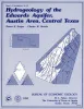
Hydrogeology of the Edwards aquifer, Austin area, central Texas | 1984 | The Edwards Formation, on the downthrown side of Mt. Bonnell fault in the Austin, Texas, area (Hays and Travis Counties), is part of the northeastern extension of the Edwards Underground Reservoir, the primary source of water in numerous counties along the Balcones Fault Zone. |
Senger, R.K., Kreitler, C.W. | Report of Investigations | Bureau of Economic Geology |