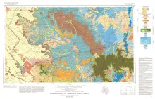
Geologic map that depicts the surface geology of Borden, Scurry, Fisher, Martin, Howard, Mitchell, and Nolan Counties and parts of Glasscock, Sterling, Coke, Runnels, Taylor, Jones, Dawson, Martin, Lynn, Garza, Kent, and Stonewall Counties. The 6-page booklet indicates geologic formations, abbreviations, and ages.
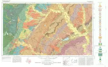
Geologic map that depicts the surface geology of Burleson, Lee, Washington, and Brazos Counties and parts of Burnet, Bell, Milam, Robertson, Madison, Grimes, Waller, Austin, Fayette, Bastrop, Caldwell, Hays, Travis, and Williamson Counties.
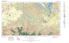
Geologic map that depicts the surface geology of Colorado, Lavaca, and Gonzales Counties, and parts of Hays, Caldwell, Bastrop, Fayette, Austin, Waller, Fort Bend, Wharton, Matagorda, Jackson, Victoria, De Witt, Karnes, Wilson, and Guadalupe Counties, Texas. The 7-page booklet indicates geologic formations, abbreviations, and ages.
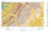
Geologic map that depicts the surface geology of Tom Green, Irion, and Reagan Counties and parts of Midland, Glasscock, Sterling, Coke, Runnels, Concho, Menard, Schleicher, Crockett, and Upton Counties, Texas.
Geothermal energy is rapidly becoming recognized, both in the United States and abroad, as a viable source of energy which can supplement fossil fuels for electric power generation. Exploration and development of geothermal reservoirs is intensifying in the western United States and Mexico, and will continue to expand as petroleum supplies diminish and costs increase. Although geothermal energy is commonly perceived as a new and exotic energy source, it is neither.