Austin Publications
| Title | Publication Year Sort ascending | Abstract | Author | Series | Publisher | |
|---|---|---|---|---|---|---|
|
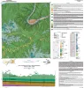
Geologic map of the Austin East quadrangle, Travis County, Texas | 2025 | Morris, J.N., Woodruff, C.M., Jr., Grunau, B.A. | Open-File Map | Bureau of Economic Geology | |
|
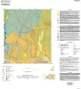
Geologic map of the Montopolis quadrangle, Travis County, Texas | 2023 | This map presents a graphic means for engineers, planners, and property owners to recognize and cope with the changes in substrate properties across this fault zone. Fault displacement has created a profound and abrupt change in land-use capabilities in this area. |
Woodruff, C.M., Jr., Morris, J.N. | Open-File Map | Bureau of Economic Geology |
|
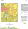
Geologic Map of the Bee Cave Quadrangle, Travis County, Texas | 2022 | Geology illustrated on this map and accompanying geologic map database was revised using field, aerial-photograph, and LiDAR interpretations following a review of previous work on the area’s geology. |
Hunt, B.B., Andrews, J.R. | Open-File Map | Bureau of Economic Geology |
|
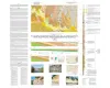
Geologic map of the Southeast Part of the Austin, Texas, 30x60 Minute Quadrangle; Central Texas Population Corridor Encompassing Bastrop and Smithville | 2008 | Collins, E.W. | Miscellaneous Map | Bureau of Economic Geology | |
|
Volcanic Features of the Austin Area, Texas | 2006 | Caran, S.C., Housh, Todd, Cherepon, Alan J. | Austin Geological Society | Austin Geological Society | |
|
Rocks, Resources, and Recollections, A Geologic Tour of the "Forty Acres" - The University of Texas at Austin Campus | 1999 | Woodruff, C.M., Jr., Kirkland, Brenda L. | Austin Geological Society | Austin Geological Society | |
|
Hydrogeology of the northern segment of the Edwards aquifer, Austin region | 1990 | Geologic mapping and fracture analysis of the Lower Cretaceous Edwards aquifer strata near Georgetown and Round Rock, Texas, were performed to provide a better understanding of the geologic framework of the Balcones Fault Zone and to provide information for assessing ground-water flow characteris |
Senger, R.K., Collins, E.W., Kreitler, C.W. | Report of Investigations | Bureau of Economic Geology |
|
Hydrogeology of the Edwards aquifer, Austin area, central Texas | 1984 | The Edwards Formation, on the downthrown side of Mt. Bonnell fault in the Austin, Texas, area (Hays and Travis Counties), is part of the northeastern extension of the Edwards Underground Reservoir, the primary source of water in numerous counties along the Balcones Fault Zone. |
Senger, R.K., Kreitler, C.W. | Report of Investigations | Bureau of Economic Geology |
|
Guide to points of geologic interest in Austin | 1976 | Trippet, A.R., Garner, L.E. | Guidebook | Bureau of Economic Geology | |
|
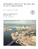
Environmental geology of the Austin area: an aid to urban planning | 1976 | The area described in this report comprises 712 square miles centered on the City of Austin. The area extends north almost to Round Rock, south to the vicinity of Buda, east to just beyond Manor, and west to about 5 miles west of Oak Hill. |
Garner, L.E., Young, Keith | Report of Investigations | Bureau of Economic Geology |