
The Eastern Shelf was a constructional platform developed on the margin of the sediment-starved Midland Basin during Late Pennsylvanian and Early Permian time. A mixed terrigenous-carbonate sedimentary province characterized the shelf during most of its history. Sediments were derived from highlands to the east and northeast. Along the outcrop in Eastland, Stephens, Young, and Jack counties, uppermost Pennsylvanian beds comprise the Harpersville Formation, a boundary-defined rock stratigraphic unit within the Cisco Group.
Mountain-bounded basins or bolsons are the most important aquifer systems throughout most of southwestern and western United States and northern Mexico. The dissection of the Presidio Bolson by the Rio Grande and its tributaries has afforded an ideal situation for detailed study of the stratigraphy of one of these important aquifer systems. The results of this investigation provide a framework for understanding the relationships between the types and distribution of bolson-fill sediments and the occurrence of ground water in desert basins in the United States and Mexico.
The Texas Coastal Zone is marked by diversity in geography, resources, climate, and industry. It is richly andowed with extensive petroleum reserves, sulfur and salt, deep-water ports, intracoastal waterways, mild climate, good water supplies, abundant wildlife, commercial fishing resources, unusual recreational potential, and large tracts of uncrowded land in close proximity to major population centers.
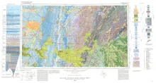
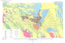
Geologic map that depicts the surface geology of Shackelford, Stephens, Palo Pinto, Callahan, and Eastland Counties and parts of Jones, Taylor, Runnels, Coleman, Brown, Comanche, Erath, Parker, and Hood Counties, Texas.
The Van Horn-Sierra Blanca region lies athwart part of the boundary between two contrasting geologic provinces. The contrast between these two provinces, splendidly displayed by Holocene landforms in the present map area, has a history that dates back to at least Late Precambrian time. This remarkable contrast led R. T. Hill (1902) to suggest the possibility of a transcontinental fracture zone passing near Van Horn and along the boundary of the provinces.