Edwards Limestone Publications
| Title | Publication Year Sort ascending | Abstract | Author | Series | Publisher | |
|---|---|---|---|---|---|---|
|
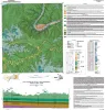
Geologic Map of the Bee Cave Quadrangle, Travis County, Texas | 2022 | Geology illustrated on this map and accompanying geologic map database was revised using field, aerial-photograph, and LiDAR interpretations following a review of previous work on the area’s geology. |
Hunt, B.B., Andrews, J.R. | Open-File Map | Bureau of Economic Geology |
|
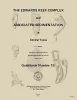
The Edwards reef complex and associated sedimentation in central Texas | 1973 | The Fredericksburg Group is one of three groups of rocks which comprise the outcropping Lower Cretaceous sediments in north central Texas. Four formations form this group; from the base upward these are the Paluxy, Walnut, Comanche Peak and Edwards (fig. 1). |
Nelson, H.F. | Guidebook | Bureau of Economic Geology |
|
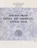
Edwards Group, surface and subsurface, central Texas | 1972 | A thick sequence of Lower Cretaceous limestone and dolomite, known traditionally and informally as Edwards," covers much of west-central Texas and composes one of the dominant physiographic elements of the State, the Edwards Plateau. |
Rose, P.R. | Report of Investigations | |
|
Edwards Formation (Lower Cretaceous), Texas: dolomitization in a carbonate platform system | 1969 | Fisher, W.L., Rodda, P.U. | Geological Circular | Bureau of Economic Geology | |
|
Symposium on Edwards Limestone in Central Texas | 1959 | Lozo, F.E., Nelson, H.F., Young, Keith, Shelburne, O.B., Sandidge, J.R. | UT Publication |