Beaumont Publications
| Title | Publication Year Sort ascending | Abstract | Author | Series | Publisher | |
|---|---|---|---|---|---|---|
|
Submerged lands of Texas, Beaumont - Port Arthur area: sediments, geochemistry, benthic macroinvertebrates, and associated wetlands | 1987 | The State-owned submerged lands of Texas encompass almost 6,000 mi2 (15,540 km2). They lie below waters of the bay-estuary-lagoon system and the Gulf of Mexico and extend 10.3 mi (16.6 km) seaward from the Gulf shoreline (fig. 1). |
White, W.A., Calnan, T.R., Morton, R.A., Kimble, R.S., Littleton, T.G., McGowen, J.H., Nance, H.S. | Submerged Lands of Texas | Bureau of Economic Geology |
|
Environmental geologic Atlas of the Texas coastal zone -- Beaumont-Port Arthur area | 1973 | The Texas Coastal Zone is marked by diversity in geography, resources, climate, and industry. |
Fisher, W.L., Brown, L.F., Jr., McGowen, J.H., Groat, C.G. | Environmental Geologic Atlas of the Texas Coastal Zone | Bureau of Economic Geology |
|
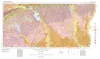
Geologic Atlas of Texas, Beaumont sheet (revised 1992) | 1968 | Geologic map that depicts the surface geology of Montgomery, San Jacinto, and Hardin Counties and parts of Madison, Trinity, Polk, Tyler, Jasper, Newton, Orange, Jefferson, Liberty, Harris, Waller, Grimes, Walker, and Robertson Counties. |
Barnes, V.E., Humble Oil and Refining Co., Shell Oil Co., Aronow, Saul, Shelby, C.A., Eargle, D.H., LeBlanc, R.J., Evans, F.G. | Geologic Atlas of Texas | Bureau of Economic Geology |