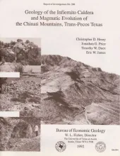
The 37-Ma-old Infiernito caldera of the northern Chinati Mountains is a major eruptive center of the mid-Tertiary volcanic field of Trans-Pecos Texas. Volcanism in the Chinati Mountains began with eruption of a sequence of rhyolitic to trachytic lavas, the precollapse lavas. These lavas progress stratigraphically upward from aphyric or sparsely porphyritic rhyolite to abundantly porphyritic trachyte; they appear to represent tapping of a compositionally zoned magma chamber.
A waterflood was begun in 1985 in Taylor-Link West San Andres unit (10 million barrels cumulative production) on the south margin of the Central Basin Platform to capture a remaining mobile oil target estimated at 20 million barrels. From the onset of injection, oil-water ratios of 0.01 or less were recorded, which indicated that a simple, layered reservoir model was inadequate to describe observed performance.
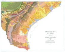
This large, 4-sheet geologic map displays more than 350 lithostratigraphic units ranging in age from Precambrian to Quaternary. In addition to the bedrock and unconsolidated surficial units, the map shows many major cultural features, such as county boundaries, cities, state and federal highways, and railroad lines. Each sheet measures 3.6 x 4.3 ft; if assembled together finished size is 7.2 x 8.6 ft. Sold as a set.
Surface fissures have been observed in many desert basins in the western United States. These surface-collapse features are usually discovered after a normally dry surface has been covered with water, either by runoff from intense rainfall, by flooding, or by irrigation. Their sudden appearance attracts the attention of local residents, especially when the fissures render unpaved roads impassable. Collapse features begin as near-surface tension fractures that are enlarged by erosion and piping.