Atlases Publications
| Title | Publication Year Sort ascending | Abstract | Author | Series | Publisher | |
|---|---|---|---|---|---|---|
|
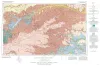
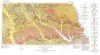
Geologic Atlas of Texas, Amarillo sheet (reprinted 1981 with limited revisions) | 1969 | Geologic map that depicts the surface geology of Carson, Gray, and Wheeler Counties and parts of Moore, Hutchinson, Roberts, Hemphill, Potter, Randall, Armstrong, Donley, and Collingsworth Counties. |
Eifler, G.K., Phillips Petroleum Co., Humble Oil and Refining Co., Frye, J.C., Leonard, A.B., Knight, G.L., Hughes, C.D., Horn, P.H. | Geologic Atlas of Texas | Bureau of Economic Geology |
|
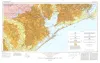
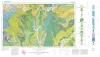
Geologic Atlas of Texas, Houston sheet (revised 1982) | 1968 | Geologic map that depicts the surface geology of Galveston and Chambers Counties and parts of Waller, Harris, Liberty, Jefferson, Orange, Brazoria, Matagorda, Wharton, and Fort Bend Counties. |
Barnes, V.E., Aronow, Saul, LeBlanc, R.J., Evans, F.G., Hinds, G.W., Holland, W.C., Van Siclen, D.C., Macon, J.W. | Geologic Atlas of Texas | Bureau of Economic Geology |
|
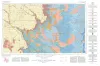
Geologic Atlas of Texas, Beaumont sheet (revised 1992) | 1968 | Geologic map that depicts the surface geology of Montgomery, San Jacinto, and Hardin Counties and parts of Madison, Trinity, Polk, Tyler, Jasper, Newton, Orange, Jefferson, Liberty, Harris, Waller, Grimes, Walker, and Robertson Counties. |
Barnes, V.E., Humble Oil and Refining Co., Shell Oil Co., Aronow, Saul, Shelby, C.A., Eargle, D.H., LeBlanc, R.J., Evans, F.G. | Geologic Atlas of Texas | Bureau of Economic Geology |
| |
Geologic Atlas of Texas, Van Horn-El Paso sheet (revised 1983) | 1968 | Geologic map that depicts the surface geology of El Paso County and parts of Hudspeth. Jeff Davis, and Culberson Counties, Texas. The 12-page booklet indicates geologic formations, abbreviations, and ages. Published in honor of E. |
Barnes, V.E., Shell Oil Co., Cities Service Petroleum Co., Dietrich, J.W., Owen, D.E., Shelby, C.A., Macon, J.W., Bridges, L.W. | Geologic Atlas of Texas | Bureau of Economic Geology |

|
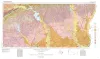
Geologic Atlas of Texas, Plainview sheet (revised 1992) | 1968 | Geologic map that depicts surface geology of Swisher, Briscoe, Hall, and Childress Counties and parts of Randall, Armstrong, Donley, Collingsworth, Hale, Floyd, Motley, and Cottle Counties. |
Barnes, V.E., Humble Oil and Refining Co., Shell Oil Co., Eifler, G.K., Knight, G.L., Hughes, C.D., Horn, P.H., Quackenbush, W.M. | Geologic Atlas of Texas | Bureau of Economic Geology |
|
Geologic Atlas of Texas, Lubbock sheet (revised 1993) | 1967 | Geologic map that depicts surface geology of Crosby, Dickens, and King Counties and parts of Hale, Floyd, Motley, Cottle, King, Lubbock, Lynn, Garza, Kent, and Stonewall Counties. The Lubbock Sheet honors the late Dr. |
Eifler, G.K., Frye, J.C., Leonard, A.B., Hentz, T.F., Barnes, V.E. | Geologic Atlas of Texas | Bureau of Economic Geology |
|
Geologic Atlas of Texas, Palestine sheet (revised 1993) | 1967 | Geologic map that depicts the surface geology of Nacogdoches, Shelby, San Augustine, Sabine, and Angelina Counties and parts of Anderson, Cherokee, Rusk, Newton, Jasper, Tyler, Polk, Trinity, Robertson, Madison, Leon, Freestone, and Panola Counties, Texas. |
Barnes, V.E., Humble Oil and Refining Co., Shell Oil Co., Pan American Petroleum Corp., Mobil Oil Co., Wright, A.C., McCallum, H.D., Wendlandt, E.A. | Geologic Atlas of Texas | Bureau of Economic Geology |
|
Geologic Atlas of Texas, Sherman sheet (revised 1991) | 1967 | Geologic map that depicts the surface geology of Montague, Cooke, Grayson, Wise, Denton, and Collin Counties and parts of Jack, Fannin, Hunt, and Clay Counties, Texas. The 16-page booklet indicates geologic formations, abbreviations, and ages. |
McGowen, J.H., Hentz, T.F., Owen, D.E., Pieper, M.K., Shelby, C.A., Barnes, V.E., Humble Oil and Refining Co., Pure Oil Co. | Geologic Atlas of Texas | Bureau of Economic Geology |

|
Geologic Atlas of Texas, Texarkana sheet (reprinted 1979 with base revised) | 1966 | Geologic map that depicts the surface geology of Lamar, Red River, Bowie, Delta, and Titus Counties and parts of Fannin, Hunt, Camp, Cass, Hopkins, Franklin, and Morris Counties, Texas. The 6-page booklet indicates geologic formations, abbreviations, and ages. |
Barnes, V.E., Humble Oil and Refining Co., Shell Oil Co., Pan American Petroleum Corp., Arkansas Geological and Conservation Commission, Oklahoma Geological Survey, McCallum, H.D., Wendlandt, E.A. | Geologic Atlas of Texas | Bureau of Economic Geology |
|
Geologic Atlas of Texas, Tyler sheet | 1964 | Geologic map that depicts the surface geology of Rains, Wood, Upshur, Marion, Harrison, Smith, and Gregg Counties and parts of Camp, Cass, Panola, Rusk, Cherokee, Anderson, Henderson, Van Zandt, Hunt, Morris, Franklin, and Hopkins Counties, Texas. |
Barnes, V.E., Shell Oil Co., Humble Oil and Refining Co., Mobil Oil Co., Pan American Petroleum Corp., Eaton, R.W., Wright, A.C., McCallum, H.D. | Geologic Atlas of Texas | Bureau of Economic Geology |