Atlases Publications
| Title | Publication Year Sort ascending | Abstract | Author | Series | Publisher | |
|---|---|---|---|---|---|---|
|
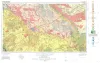
Geologic Atlas of Texas, Pecos sheet | 1976 | Geologic map that depicts the surface geology of Loving, Crane, and Ward Counties and parts of Ector, Midland, Upton, Pecos, Reeves, Crockett, and Winkler Counties, Texas. The 5-page booklet indicates geologic formations, abbreviations, and ages. |
Barnes, V.E., Eifler, G.K., Shell Oil Co., Cities Service Petroleum Co., Brown, J.B. | Geologic Atlas of Texas | Bureau of Economic Geology |
|
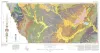
Geologic Atlas of Texas, Crystal City-Eagle Pass sheet | 1976 | Oversize color geologic map that depicts surface geology of Dimmit, LaSalle, and McMullen Counties and parts of Maverick, Zavala, Frio, Atascosa, Karnes, Wilson, Live Oak, Jim Wells, Duval, and Webb Counties, Texas. The 6-page booklet indicates geologic formations, abbreviations, and ages. |
Barnes, V.E., Humble Oil and Refining Co., Shell Oil Co., Amerada Petroleum Corp., Mobil Oil Co., Owens, Frith, Howeth, Ike, Brown, T.E. | Geologic Atlas of Texas | Bureau of Economic Geology |

|
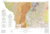
Environmental geologic Atlas of the Texas coastal zone -- Corpus Christi area | 1976 | The Texas Coastal Zone is marked by diversity in geography, resources, climate, and industry. |
Brown, L.F., Jr., Brewton, J.L., McGowen, J.H., Evans, T.J., Fisher, W.L., Groat, C.G. | Environmental Geologic Atlas of the Texas Coastal Zone | Bureau of Economic Geology |
|
Environmental geologic Atlas of the Texas coastal zone -- Port Lavaca area | 1976 | The Texas Coastal Zone is marked by diversity in geography, resources, climate, and industry. |
McGowen, J.H., Proctor, C.V., Jr., Brown, L.F., Jr., Evans, T.J., Fisher, W.L., Groat, C.G. | Environmental Geologic Atlas of the Texas Coastal Zone | Bureau of Economic Geology |

|
Geologic Atlas of Texas, Hobbs sheet | 1976 | Geologic map that depicts the surface geology of Gaines and Andrews Counties and parts of Yoakum, Terry, Dawson, Martin, Winkler, Ector, and Midland Counties, Texas. The 5-page booklet indicates geologic formations, abbreviations, and ages. |
Barnes, V.E., Eifler, G.K., Reeves, C.C., Kottlowski, F.E., Norman, D.M., Sherrod, C.H., Hansen, J.J. | Geologic Atlas of Texas | Bureau of Economic Geology |
|
Geologic Atlas of Texas, Laredo sheet | 1976 | Geologic map that depicts the surface geology of parts of Webb, Duval, Jim Wells, Kleberg, Brooks, Jim Hogg, and Zapata Counties |
Barnes, V.E., Mobil Oil Co., Shell Oil Co., Humble Oil and Refining Co., Owens, Frith, Brewton, J.L., Tobin, Edward, Martin, R.G. | Geologic Atlas of Texas | Bureau of Economic Geology |

|
Geologic Atlas of Texas, Corpus Christi sheet | 1975 | Geologic map that depicts the surface geology of Nueces County and parts of Jim Wells, San Patricio, Aransas, Kleberg, and Kenedy Counties. |
Barnes, V.E., Aronow, Saul, Humble Oil and Refining Co., Martin, R.G., Maxson, M.J., Wyeth, J.C., Knupke, J.A., Buck, C.E. | Geologic Atlas of Texas | Bureau of Economic Geology |

|
Geologic Atlas of Texas, Beeville-Bay City sheet (revised 1987) | 1975 | Geologic map that depicts the surface geology of Goliad, Refugio, and Calhoun Counties and parts of Karnes, De Witt, Victoria, Jackson, Matagorda, Aransas, San Patricio, Bee, and Live Oak Counties. The 4-page booklet indicates geologic formations, abbreviations, and ages. |
Barnes, V.E., Brown, T.E., Brewton, J.L., Aronow, Saul, Eargle, D.H., Morton, R.G., Maxson, M.J., Wyeth, J.C. | Geologic Atlas of Texas | Bureau of Economic Geology |

|
Geologic Atlas of Texas, Brownfield sheet | 1974 | Geologic map that depicts the surface geology of Cochran and Hockley Counties and parts of Bailey, Lamb, Yoakum, Terry, Hale, Lubbock, and Lynn Counties. |
Barnes, V.E., Eifler, G.K., Reeves, C.C., Kottlowski, F.E., Brown, J.B., Briscoe, J.A., DesCamps, J.R., Cities Service Petroleum Co. | Geologic Atlas of Texas | Bureau of Economic Geology |

|
Geologic Atlas of Texas, San Angelo sheet | 1974 | Geologic map that depicts the surface geology of Tom Green, Irion, and Reagan Counties and parts of Midland, Glasscock, Sterling, Coke, Runnels, Concho, Menard, Schleicher, Crockett, and Upton Counties, Texas. |
Barnes, V.E., Eifler, G.K., Shell Oil Co., Southern Minerals Corp., Humble Oil and Refining Co., Cannon, Joe, Brown, W.J., Swartz, G.D. | Geologic Atlas of Texas | Bureau of Economic Geology |