Reports of Investigations
-
Books & Reports
- Reports of Investigations
- Guidebooks
- Udden Series
- Geological Circulars
- Down To Earth
- Atlases of Major Oil and Gas Reservoirs
- Texas Memorial Museum Publications
- Environmental Geologic Atlas of the Texas Coastal Zone
- Mineral Resource Circulars
- Other Reports
- Seminars and Workshops
- Handbooks
- Submerged Lands of Texas
- Symposia
- Annual Reports
- Open File Reports
-
Maps & Cross Sections
- Thematic Maps
- Miscellaneous Maps, Charts & Sections
- Geologic Atlas of Texas
- STATEMAP Project Maps
- Geologic Quadrangle Maps
- Cross Sections
- Highway Geology Map
- Energy and Mineral Resource Maps
- Shoreline Change and Other Posters
- Wilcox Group, East Texas, Geological / Hydrological Folios
- Bouguer Gravity Atlas of Texas
- River Basin Regional Studies
- Featured Maps
- Posters
- Teachers & the Public
-
Geological Society Publications
- Gulf Coast Association of Geological Societies
- Alabama Geological Society
- Austin Geological Society
- Corpus Christi Geological Society
- Houston Geological Society
- Lafayette Geological Society
- Mississippi Geological Society
- New Orleans Geological Society
- South Texas Geological Society
- GCS SEPM Publications
- Historic BEG & UT Series


Geology of the Solitario Dome, Trans-Pecos Texas. Digital Download
RI0240D
For a print version: RI0240.
RI0240D. Geology of the Solitario Dome, Trans-Pecos Texas: Paleozoic, Mesozoic, and Cenozoic Sedimentation, Tectonism, and Magmatism. C. D. Henry and W. R. Muehlberger, Editors. 182 p., 73 figs., 2 tables, 1 appendix, 2 oversize color plates, 1996. doi.org/10.23867/RI0240D/RI0240D. Downloadable PDF.
To purchase this publication in book format, please order RI0240.
About This Publication
This report comprises 12 chapters that describe the structural, sedimentologic, volcanologic, petrographic, and geochronologic features of the Solitario.
ABSTRACT
The Solitario is a circular, 14- to 16-krn-diameter, mid-Tertiary laccolithic dome and caldera in southern Trans-Pecos Texas; it is among the world's largest laccoliths. Rocks ranging in age from Cambrian through Quaternary crop out in and around the dome. The oldest rocks, exposed in the core of the dome, are Cambrian through Pennsylvanian clastic, carbonate, and silicic sedimentary rocks, deposited in the ocean basin that lay south of the Paleozoic North American continent. A relatively thin sequence of Cambrian through Mississippian shale, sandstone, chert, novaculite, and limestone was deposited slowly in a passive-margin setting. Cambrian-Ordovician shale commonly contains blocks of the other rocks that are either olistoliths or highly boudinaged beds. A much thicker sequence of Upper Mississippian-Lower Pennsylvanian shale and sandstone was deposited rapidly in the Ouachita foreland basin. All these rocks were folded and thrust northwestward during late Paleozoic Ouachita-Marathon deformation. Individual folds in well-exposed areas that are held up by resistant novaculite and chert beds are asymmetric to overturned and verge northwestward. A complex, folded thrust in the eastern part of the Solitario is cut by numerous northwest-striking cross faults that parallel the direction of transport. The northern part of the Paleozoic outcrop consists mostly of poorly exposed but, where observed, intricately folded Ordovician shale.
Cretaceous sedimentary rocks were deposited over the region following a long hiatus during which the Paleozoic foldbelt eroded. The basal Cretaceous conglomerate is a terrestrial deposit (alluvial fans) that developed on a surface cut in the Paleozoic rocks. Overlying Cretaceous clastic and carbonate rocks are shallow-marine deposits that accumulated on the eastern flank of the Chihuahua trough, a deep basin related to rifting that formed the Gulf of Mexico. Alternation of massive limestone with marl or shale indicates deposition in intertidal to subtidal environments with varying contributions of fine terrigenous material.
The Solitario lies at the eastern edge of Laramide (early Tertiary) deformation and is superposed upon the Laramide Terlingua uplift and Fresno-Terlingua monocline. The monocline probably overlies a high-angle reverse fault in basement, and both the monocline and uplift are cut by numerous east-northeast-striking strike-slip faults. The southwestern rim of the Solitario aligns with the northern end of the northwest-striking Fresno monocline. Cretaceous rocks within the Solitario were largely flatlying before doming but show evidence of Laramide deformation, including east-northeast-striking strike-slip faults, calcite-filled veins and fractures, and tectonic stylolites.
During the late Eocene, the Solitario underwent a complex sequence of laccolith, sill, and dike injection; doming; ash-flow eruption; caldera collapse; and intracaldera volcanism and sedimentation. 40~r/39ag~ers demonstrate that Solitario magmatism occurred in three pulses at 36.0, 35.4, and 35.0 Ma. During the first pulse, abundant rhyolitic to trachytic sills, dikes, and small laccoliths were emplaced into both the relatively undefonned Cretaceous sequence and into the structurally complex Paleozoic rocks. The main laccolith that uplifted the dome was emplaced during the second, most voluminous pulse. The laccolith probably intruded Paleozoic rocks along the sole thrust of the Ouachita-Marathon system at a depth of 3 to 4 km. The dome is generally doubly hinged, resembling the geometry of many laccoliths worldwide. Cretaceous rocks dip15 degrees to 50 degrees radially outward in a continuous rim; however, the southwestern rim of the Solitario is substantially steeper than other sides, probably because doming was superposed upon the Laramide monocline. Cretaceous rocks flatten away from the dome along a concave-upward hinge. Steep dips were maintained well into the interior of the dome; probably only an area 2 to 3 krn wide in the center of the dome was flat. Radial faults and fractures developed over the dome as it rose, commonly reactivating east-northeast-striking Laramide faults. Quartz-phyric dikes intruded along these fractures on the north and west flanks of the dome. Ash-flow eruption along faults over the roof led to collapse of a 6- x 2-km, north-trending caldera over the south and central parts of the dome. Collapse was greater in the southern part of the caldera, where ponded ash-flow tuff buries older rocks, than in the northern part, where exposed Paleozoic and Cretaceous rocks dip steeply southward. 40Ar/39Ar ages averaging 35.4 Ma on the quartz-phyric, radial dikes and the ash-flow tuff probably indicate the age of the laccolith and doming. The caldera was filled by a complex sequence of debris-flow and debris-avalanche deposits, megabreccia blocks as much as 200 m in diameter, trachyte lava, and small-volume ash-flow tuff. Late subsidence within the caldera produced a north-striking syncline. The final pulse, at 35.0 Ma, consisted of several small laccoliths or stocks and numerous dikes in caldera fill and along the ring fracture.
The Solitario is nearly surrounded by Tertiary volcanic, volcaniclastic, and intrusive rocks that are representative of magmatism in Trans-Pecos Texas. These rocks erupted from numerous local and distant sources between 47 and at least 24 Ma ago. Most postdate 36- to 35-Ma Solitario magmatism, but a group of peralkaline rhyolite lava domes erupted north and west of the Solitario 35.4 Ma ago, contemporaneous with the main pulse of magmatism in the Solitario. A thick, coarse conglomerate shed from the Solitario dome is interbedded with the volcanic and volcaniclastic rocks. Igneous rocks emplaced before about 30 Ma ago are part of a subduction-related volcanic arc related to convergence off the west coast of North America. Igneous rocks emplaced after that time are related to Basin and Range extension, including distinctive alkali basalts emplaced contemporaneously with initial faulting about 25 Ma ago. The Solitario lies in the eastern part of the Basin and Range province. It occupies a relatively unfaulted block surrounded by Basin and Range normal and strike-slip faults.
Keywords: ash-flow tuff, basin and range, Bee Mountain Basalt, Big Bend, Black Mesa, Bofecillos Mountains, Boquillas Formation, Buda Limestone, Caballos Novaculite, caldera, Chisos, Cretaceous, Dagger Flat Sandstone, Del Carmen Limestone, Del Rio Clay, dike, dome, foldbelt, Fort Peña Formation, Fresno Formation, Glen Rose Limestone, K-Ar, karst, laccolith, Laramide, magmatism, Marathon Formation, Maravillas Formation, Mitchell Mesa Rhyolite, monocline, Mule Ear Spring Tuff, novaculite, ore deposits, Ouachita, Paleozoic, Pen Formation, Rawls Formation, rhyolite, Santa Elena Limestone, shutup, sill, Solitario, Sue Peaks Formation, Tascotal Formation, Terlingua uplift, Tertiary, Tesnus Formation, trachyte, Trans-Pecos Texas, Tule Mountain Trachyandesite, Woods Hollow, Yucca Formation
CONTENTS
Abstract
Introduction
Regional Setting
Geomorphology
Previous Work
Access
Paleozoic Stratigraphy, by William R. Muehlberger and Christopher D. Henry
Introduction and Regional Setting
Dagger Flat Sandstone
Marathon Formation
White Shale Member (Informal)
Undifferentiated Marathon Formation
Rodrigues Tank Sandstone Member
Complexities of the Marathon Formation
Fort Peña Formation
Woods Hollow Shale
Maravillas Formation
Caballos Novaculite
Tesnus Formation
Paleozoic Structure, by William R. Muehlberger
Regional Setting
Tesnus Homocline
Righthand Shutup Folded Area
Northern Folded Area
Tres Papalotes Folded Area
Structure North of the Solitario Fault
Solitario Fault
Structure of the Marathon Formation
Cretaceous Stratigraphy, by C. Larry McCormick, Charles I. Smith. and Christopher D. Henry
Introduction and Regional Setting
Lower Cretaceous Rocks
Shutup Conglomerate
Correlation and Terminology
Description, Interpretation, and Age
Yucca Formation
Correlation and Terminology
Description, Interpretation, and Age
Glen Rose Limestone
Correlation and Terminology
Description, Interpretation, and Age
Del Carmen Limestone
Correlation and Terminology Description, Interpretation, and Age
Sue Peaks Formation
Correlation and Terminology
Description, Interpretation, and Age
Santa Elena Limestone
Correlation and Terminology
Description, Interpretation, and Age
Upper Cretaceous Rocks
Del Rio Clay
Buda Limestone
Boquillas Formation
Pen Formation
Laramide Deformation of the Solitario Area, by Richard J. Erdlac, Jr.
Regional Setting of Laramide Deformation
The Terlingua Uplift
Laramide Structures on the Southern Part of the Terlingua Uplift
Folds
Thrust and Contraction Faults
Northeast-Striking Fault Systems
Tectonic Stylolites
Laramide Structures in the Solitario
Northeast-Striking Faults
Veins and Fractures
Tectonic Stylolites
Timing and Origin of the Terlingua Uplift
Age of Uplift
Origin of Uplift
Summary
Igneous Geology of the Solitario, by Christopher D. Henry
Predoming Magmatism
Rim Sills and Related Volcanic Rocks
Intrusions (Tirl, Tir2, Titl)
Volcanic Equivalents (Tvrl, Tvrlt, Tvr2)
Central Intrusions
Porphyritic Syenite (Tis)
Rhyolite Breccia (Tirx)
Rhyolite (Tir3) and Intrusive Breccia (Tir3x) of Needle Peak
Intrusions Contemporaneous with Doming
Quartz-Phyric Rhyolite Dikes (Tir4)
Breccia Dikes (Tbd)
Caldera-Fill Ash-Flow Tuff, Debris Deposits (Breccia), and Lava
Tx 1
Ash-Flow Tuff of the Solitario (Tas)
Ash-Flow Tuff Vent (Tasv)
Tx2
Tvt
Tx6
Overall Sequence
The Solitario Laccolith
Late Intrusions
Biotite Quartz Trachyte (Tiq)
Porphyritic Trachyte Dome (Tit2)
Porphyritic Rhyolite (Tir5)
Trachyte(?) (Tit3)
Coarsely Porphyritic Rhyolite (Tir6)
Late(?) Basalt (Tib)
Tertiary Volcanic, Volcaniclastic, and Intrusive Rocks Adjacent to the Solitario, by Christopher D. Henry and Linda L. Davis
Introduction
Jeff Conglomerate (Tj)
Chisos Group
Regional Stratigraphy
Alamo Creek Basalt (Tcac) Sedimentary Strata of the Undifferentiated Chisos Group (Tc)
Bee Mountain Basalt (Tcbm)
Mule Ear Spring Tuff (Tcm)
Tule Mountain Trachyandesite (Tctm)
Devils Graveyard Formation (Tdg)
Solitario Conglomerate (Tsg and Tsl)
Terneros Creek Rhyolite
Mitchell Mesa Rhyolite (Tmm)
Fresno and Tascotal Formations (Tf and Tta)
Regional Stratigraphy
Fresno Formation (Tfr, Tft, Tftp, Tf)
Tascotal Formation (Tta)
Rawls Formation (Tr)
Regional Stratigraphy
Tuff of Fresno Canyon (Trla) of the Leyva Canyon Member
Basalt and Porphyritic Basalt (Trsb and Trsbp) of the Sauceda Lavas Member
Rancho Viejo Tuff (Trr)
Basalt and Trachyte Lavas (Trab and Trat) of the Alazan Lavas Member
Closed Canyon Formation and Related Dikes (Tmb, Tms, and Tim)
Intrusive Rocks
Rhyolite (Tir) of Contrabando Dome
Peralkaline Quartz Trachyte of Solitario Peak (Tiqt)
Syenogabbro or Hawaiite (Tig)
Trachyandesite (Tita)
Black Mesa Dome and Intrusion, by Christopher D. Henry and Richard J. Erdlac, Jr.
Geochronology of the Solitario and Adjacent Volcanic Rocks, by Christopher D. Henry and Michael J. Kunk
Introduction
Previous Work
Samples
Methodology
40Ar/39Ar and K-Ar Data and General Interpretation
Timing of Magmatism
47-Ma Alamo Creek Basalt
36- to 35-Ma Solitario
35.4.-Ma Terneros Creek Rhyolite
34- to 33-Ma Late Chisos Volcanism
Approximately 33- to 31- Ma Fresno Lavas
27.3. to 27.1 -Ma Rawls Volcanism
25- to 24-Ma Basalts of the Closed Canyon Formation
Comparison of 40Ar/39Ar and K-Ar Ages
Structure of the Solitario Dome and Caldera, by Christopher D. Henry and William R. Muehlberger
Structure of the Dome Cretaceous Rim
Central Basin
Amplitude of the Dome
Volume of the Main Laccolith
Amount of Extension over the Dome
Faults Related to Doming
Discussion
Depth and Horizon of Emplacement of the Main Laccolith
Structure of the Solitario Caldera
Geometry of the Caldera
The Collapse Block
Late Subsidence
Gravity and Aeromagnetic Data
Discussion
Basin and Range Fault System, by Christopher D. Henry and Richard J. Erdlac, Jr.
Basin and Range Extensional Province of Western North America
Basin and Range Faulting of the Solitario-Bofecillos Block
Redford-Lajitas Fault Zone and Tascotal Mesa Fault in This Map Area
North-Northwest-Striking Normal Faults of the Terlingua Uplift Southeast of the Solitario
Origin of the Solitario-Bofecillos Block
Amount of Extension and Possible Quaternary Faulting
Solution-Collapse Features, by Christopher D. Henry
Economic Geology, by Christopher D. Henry
Base and Precious Metals in the Solitario
Molybdenum
Ag-Pb-Zn-Cu-Au Vein: The "Gold Mine"
Ag-Pb-Zn-Mn Vein: The "Manganese Mine"
Manganese Deposits in the Caballos Novaculite
Uranium and Copper(?) Prospect
Mercury Mineralization of the Terlingua District
Fresno and Whitroy Mines
Contrabando Dome
Pickens Oil (La Escondida) Prospect
Other Prospects
Areas of Silicification
Fluorspar
Synthesis and Directions for Further Research, by Christopher D. Henry, William R. Muehlberger, C. Larry McCormick, Richard J. Erdlac, Jr., Michael J. Kunk, Linda L. Davis, and Charles I. Smith
Precambrian North American Craton
Paleozoic Sedimentation
Paleozoic Deformation
Mesozoic Erosion, Rifting, and Marine Deposition
Laramide Deformation
Tertiary Magmatism
Pre-Solitario Activity
The Solitario
Terneros Creek Rhyolite
Black Mesa
Post-Solitario Activity
Basin and Range Faulting
Acknowledgments
References
Appendix
Figures
1. Location of the Solitario map area and the Big Bend Ranch State Park
2. Satellite image of the Solitario and adjacent parts of the Big Bend region
3. Oblique aerial view of the Solitario. looking northeastward across the dome
4. The Solitario, near the junction of six major tectonic provinces
5. Diagram of major geomorphic elements of the Solitario map area
6. Previous geologic maps that cover parts of the Solitario map area
7. Stratigraphy of Paleozoic rocks exposed in the Solitario
8. Regional setting and distribution of Ouachita-facies Paleozoic rocks, Ouachita-Marathon orogen, in Texas and adjacent areas
9. Geologic map between McGuirks Tanks and High Tank
10. View southwest across the Tesnus homocline and Lower Shutup to rim of Solitario
11. View southwest across the Tesnus homocline to Fresno Peak. capped by Del Carmen Limestone
12. View west in an approximate down-plunge view of the Maravillas-Caballos folds and thrust in the Righthand Shutup Folded Area
13. View north at syncline in lower Tesnus Formation about 300 m south-southwest of Tres Papalotes
14. View south to Lion Mountain
15. Recumbent fold hinges in limestone blocks encased in shale of the Marathon Formation
16. Shale-rich Marathon Formation with boudins of thin limestone beds
17. Black chert showing domino block tilting of Marathon Formation
18. View east at blue-gray limestone showing thrust(?) truncation dipping south
19. Late Paleozoic tectonic elements and early Mesozoic paleogeography
20. Early Cretaceous tectonic elements and paleogeography
21. Correlation chart of Lower Cretaceous formations, southern Trans-Pecos Texas
22. Shutup Conglomerate near entrance to Lefthand Shutup
23. Two massive limestones at the base of the Del Carmen Limestone in the northern rim of the Solitario
24. Small biohermal masses in Del Carmen Limestone in north wall of Lefthand Shutup
25. Middle part of Santa Elena Limestone. Lefthand Shutup
26. Outer edge of the western rim of the Solitario
27. Contact between thick, bedded, nodular Buda Limestone and overlying, thin-bedded Boquillas Formation
28. Laramide faults and folds within Trans-Pecos Texas and northeastern Mexico
29. Tectonic map of the western part of the Terlingua uplift
30. East along the Terlingua monocline
31. Westward along the Lowes Valley fault zone from the northwest flank of Black Mesa
32. Schematic diagram of the intersection of the Lowes Valley fault zone and the Fresno monocline
33. Histogram of tectonic stylolite teeth trends measured within the Cretaceous strata on the Terlingua uplift and in the rim of the Solitario
34. Example of pure shear of calcite veins within the Lefthand Shutup
35. Three-stage model for Laramide-age development of the Terlingua-Solitario push-up block
36. Sill of porphyritic rhyolite in Shutup Conglomerate at entrance of Lefthand Shutup
37. View to east-northeast of intrusion of quartz-phyric rhyolite in Del Carmen Limestone, Righthand Shutup
38. Extremely large blocks of the caldera wall slumped into the caldera immediately following ash-flow eruption and caldera collapse
39. Densely welded ash-flow tuff of the Solitario, showing distinctive thick, dark pumice
40. Low-level aeromagnetic map of the Solitario
41. Distribution of the Mule Ear Spring Tuff
42. Ash-flow tuff vent in the ridge of Caballos Novaculite west of Tres Papalotes and 1.5 km east of the caldera
43. Outcrop of ash-flow tuff vent
44. Coarse debris-flow deposit in unit Tx4
45. Coarse, massive debris-flow deposit in unit Tx6
46. Aeromagnetic map of southern Trans-Pecos Texas
47. Calderas and other volcanic centers of southern Trans-Pecos Texas and adjacent Chihuahua, Mexico
48. Diagrammatic stratigraphy of Tertiary rocks around the Solitario
49. Distribution of the Jeff Conglomerate in the Solitario map area
50. Jeff Conglomerate in Fresno Canyon southwest of the Solitario
51. Chisos Group in the west face of South Lajitas Mesa
52. Solitario Conglomerate north of Arroyo Segundo and west of Fresno Canyon
53. Intrusion of peralkaline quartz trachyte
54. Geologic map of the Black Mesa area southeast of the Solitario
55. Black Mesa dome southeast of the Solitario
56. Histogram of 40Ar/39Ar and K-Ar ages determined on rocks of the Solitario and volcanic rocks of the Bofecillos Mountains area; histogram of 40Ar/39Ar ages from the Solitario, Terneros Creek Rhyolite, and Black Mesa
57. Representative age spectra
58. Plot of 40Ar/39 Ar and K-Ar ages
59. View to the southeast of southwestern rim of Solitario. showing moderately steeply dipping Cretaceous rocks, mostly Glen Rose Formation
60. Southwestern part of Solitario, showing Cretaceous rocks in angular unconformity over Pennsylvanian Tesnus Formation
61. View to northeast of south rim of the Solitario, east of the Lower Shutup, showing monocline related to doming, mostly in Santa Elena Limestone
62. View to the northeast of the southwestern rim of the Solitario and the Fresno monocline where the two join
63. View southwest across the southeastern rim of the Solitario
64. Rose diagram of faults in the rim of the Solitario and along the Fresno monocline immediately south of the Solitario
65. Gravity map and profiles
66. Diagrammatic evolution of caldera collapse
67. Generalized map of Basin and Range faults, contemporaneous basalts, and basin-fill deposits of southern Trans-Pecos Texas and adjacent Chihuahua, Mexico
68. Surface of west-northwest-striking Basin and Range fault along Highway 170 approximately 4 km west of Lajitas
69. Geologic map of the Tascotal Mesa fault where it cuts 35.4-Ma Terneros Creek Rhyolite and 27.1-Ma Rawls Formation in the northern part of the map area
70. Shallow caves developed in massive Santa Elena Limestone in the western rim of the Solitario
71. Faults and folds formed during late Paleozoic Ouachita-Marathon deformation
72. Faults active during early Cenozoic Laramide deformation
73. Faults and hinges active during doming or caldera collapse
Tables
1. Revised stratigraphy of the Rawls Formation
2. 40Ar/39Ar and K-Ar data from the Solitario
Appendix Tables
A1. Fossils of the Marathon Formation
A2. Fossils in Cretaceous formations of the Solitario
A3. Petrography of Solitario igneous rocks
A4. Chemical analyses of igneous rocks, the Solitario and adjacent areas
A5. Petrographic data of Tertiary volcanic and intrusive rocks
Plates
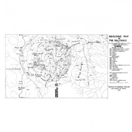
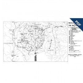
1. Geologic map of the Solitario dome, Trans-Pecos Texas
2. Geologic cross sections of the Solitario dome, Trans-Pecos Texas
Citation
Henry, C. D., and Muehlberger, W. R., editors, 1996, Geology of the Solitario Dome, Trans-Pecos Texas: Paleozoic, Mesozoic, and Cenozoic Sedimentation, Tectonism, and Magmatism: The University of Texas at Austin, Bureau of Economic Geology, Report of Investigations No. 240, 182 p. doi.org/10.23867/RI0240D.