Reports of Investigations
-
Books & Reports
- Reports of Investigations
- Guidebooks
- Udden Series
- Geological Circulars
- Down To Earth
- Atlases of Major Oil and Gas Reservoirs
- Texas Memorial Museum Publications
- Environmental Geologic Atlas of the Texas Coastal Zone
- Mineral Resource Circulars
- Other Reports
- Seminars and Workshops
- Handbooks
- Submerged Lands of Texas
- Symposia
- Annual Reports
- Open File Reports
-
Maps & Cross Sections
- Thematic Maps
- Miscellaneous Maps, Charts & Sections
- Geologic Atlas of Texas
- STATEMAP Project Maps
- Geologic Quadrangle Maps
- Cross Sections
- Highway Geology Map
- Energy and Mineral Resource Maps
- Shoreline Change and Other Posters
- Wilcox Group, East Texas, Geological / Hydrological Folios
- Bouguer Gravity Atlas of Texas
- River Basin Regional Studies
- Featured Maps
- Posters
- Teachers & the Public
-
Geological Society Publications
- Gulf Coast Association of Geological Societies
- Alabama Geological Society
- Austin Geological Society
- Corpus Christi Geological Society
- Houston Geological Society
- Lafayette Geological Society
- Mississippi Geological Society
- New Orleans Geological Society
- South Texas Geological Society
- GCS SEPM Publications
- Historic BEG & UT Series
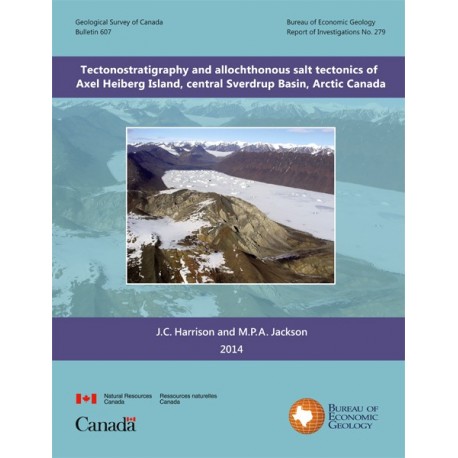
Tectonostratigraphy and Allochthonous Salt Tectonics of Axel Heiberg Island, Central Sverdrup Basin, Arctic Canada
RI0279
Tectonostratigraphy and Allochthonous Salt Tectonics of Axel Heiberg Island, Central Sverdrup Basin, Arctic Canada, by J. C. Harrison and M. P. A. Jackson. Copublished with Geological Survey of Canada. 124 p., 76 figs., 2014. ISBN: 978-100-23499-1. doi.org/10.4095/293840. Print
RI0279. Tectonostratigraphy and Allochthonous Salt Tectonics of Axel Heiberg Island, Central Sverdrup Basin, Arctic Canada, by J. C. Harrison and M. P. A. Jackson. Copublished with the Geological Survey of Canada (as Bulletin 607). 124 p., 76 figs., 2014. Resume in French, Abstract in English. ISSN: 0068-7626. ISBN: 978-100-23499-1, doi.org/10.4095/293840.
Please Note: This publication is not available on CD-ROM or as a download from The Bureau Store.
About This Publication (excerpted from the Abstract)
The authors examine Axel Heiberg Island (northern Nunavut), which contains the thickest Mesozoic section in the Sverdrup Basin. The island, only 370 km long, is second only to Iran in its concentration of exposed diapirs: 46 diapirs of Carboniferous evaporites and associated minibasins. The Axel Heiberg canopy is one of only three known exposed evaporite canopies.
ABSTRACT
Axel Heiberg Island (northern Nunavut) contains the thickest Mesozoic section in Sverdrup Basin. The approximately 370-km-long island is second only to Iran in its concentration of exposed diapirs. Forty-six diapirs of Carboniferous evaporites and associated minibasins are impressively exposed on the island. Regional anticlines, which formed during the Paleogene Eurekan Orogeny, trend roughly north on a regular approximately 20 km wavelength and probably detach on the autochthonous Carboniferous Otto Fiord Formation evaporites. These evaporites comprise halite overlain by thick anhydrite containing thin limestone beds. Unlike the rest of the island, a 60-km-wide area, known as the wall-and-basin region, has bimodal fold trends and irregular (<10 km) fold wavelengths. Here, crooked, narrow walls of superficially gypsified anhydrite crop out in tight anticline cores, which are separated by wider synclinal minibasins. We interpret the wall-and-basin region to detach on a shallow, partly exposed canopy of coalesced allochthonous evaporite sheets. This inference is based on four lines of evidence: 1) a halving of fold wavelength relative to folds outside the wall-and-basin region, 2) the exposure of anomalously young strata of Paleogene and Late Cretaceous age, 3) the occurrence of clustered equant minibasins having similarities to those in the northern Gulf of Mexico, and 4) a strikingly uniform level of piercement pointing to a stratiform allochthonous source layer. A canopy would require an evaporite depocentre, which may have ponded in a sinistral pull-apart basin of Carboniferous age.
Strata record a salt-tectonic history spanning the Late Triassic (Norian) epoch to the Paleogene period. Stratigraphic thinning against diapirs and angular unconformities up to 90 degrees indicate mild regional shortening in which diapiric roof strata were bulged up and flanking strata steepened. This bulging culminated during Hauterivian times, when diapiric evaporites broke out and coalesced at the surface to form a canopy. As the canopy was buried, it yielded second-generation diapirs, which rose between minibasins subsiding into the canopy. A consistent high emplacement level indicates that all exposed diapirs inside the wall-and-basin region rose from the canopy. In contrast, diapirs along the wall-and-basin margins were sourced in autochthonous salt as first-generation diapirs. Apart from the large diapir-centered unconformities, Jurassic-Cretaceous depositional evidence of salt tectonics also includes submarine debris flows and boulder conglomerates shed from at least three emergent diapirs.
The report area's geological history includes six main tectonostratigraphic phases in the wider Arctic area, beginning with Carboniferous rifting and ending with the Paleogene Eurekan Orogeny. Extreme local relief, tectonic slide blocks, steep talus fans, and subaerial debris flows suggest that many wall-and-basin diapirs continue to rise today. Freeboard calculations suggest that the rise of diapirs having surface relief of even 400 m could be driven purely by gravitational loading, but additional mild tectonic shortening cannot be ruled out. The Axel Heiberg canopy is one of only three known exposed evaporite canopies, each revealed at a different structural level: above the canopy (Axel Heiberg), through the canopy (Great Kavir, Iran), and possibly beneath a canopy (Sivas Basin, Turkey).
Keywords: Canada, salt tectonics, tectonostratigraphy, Axel Heiberg Island, Sverdrup Basin, diapirs, minibasins
CONTENTS (excerpted)
Abstract
Resume
Introduction
Tectonostratigraphic History
Structure
Conclusions
Acknowledgments
References
Citation
Harrison, J. C., and Jackson, M.P.A., 2014, Tectonostratigraphy and Allochthonous Salt Tectonics of Axel Heiberg Island, Central Sverdrup Basin, Arctic Canada: The University of Texas at Austin, Bureau of Economic Geology, Report of Investigations No. 279, 241 p.
