Reports of Investigations
-
Books & Reports
- Reports of Investigations
- Guidebooks
- Udden Series
- Geological Circulars
- Down To Earth
- Atlases of Major Oil and Gas Reservoirs
- Texas Memorial Museum Publications
- Environmental Geologic Atlas of the Texas Coastal Zone
- Mineral Resource Circulars
- Other Reports
- Seminars and Workshops
- Handbooks
- Submerged Lands of Texas
- Symposia
- Annual Reports
- Open File Reports
-
Maps & Cross Sections
- Thematic Maps
- Miscellaneous Maps, Charts & Sections
- Geologic Atlas of Texas
- STATEMAP Project Maps
- Geologic Quadrangle Maps
- Cross Sections
- Highway Geology Map
- Energy and Mineral Resource Maps
- Shoreline Change and Other Posters
- Wilcox Group, East Texas, Geological / Hydrological Folios
- Bouguer Gravity Atlas of Texas
- River Basin Regional Studies
- Featured Maps
- Posters
- Teachers & the Public
-
Geological Society Publications
- Gulf Coast Association of Geological Societies
- Alabama Geological Society
- Austin Geological Society
- Corpus Christi Geological Society
- Houston Geological Society
- Lafayette Geological Society
- Mississippi Geological Society
- New Orleans Geological Society
- South Texas Geological Society
- GCS SEPM Publications
- Historic BEG & UT Series
Middle-Upper Miocene Depositional Sequences of the Texas Coastal Plain and Continental Shelf:
RI0174
For a downloadable, digital version: RI0174D.
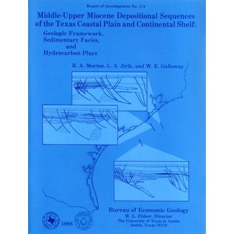
RI0174. Middle-Upper Miocene Depositional Sequences of the Texas Coastal Plain and Continental Shelf: Geologic Framework, Sedimentary Facies, and Hydrocarbon Plays, by R. A. Morton, L. A. Jirik, and W. E. Galloway, assisted by Nancy Banta, Emil Bramson, Richard Erdlac, and Denise Hanna. 40 p., 24 figs., 2 tables, 1 appendix, 7 plates, 1988. ISSN: 0082335X: Print.
To purchase this publication as a downloadable PDF, please order RI0174D.
ABSTRACT
Middle-upper Miocene depositional sequences of offshore Texas represent the last regionally significant influx of terrigenous elastic sediments into the western Gulf Coast Basin. Interpretations made on the basis of well logs and seismic lines indicate that sediments of this depositional episode constitute a major regressive wedge bounded above and below by the widespread Bigenerina A and Amphistegina B shales, respectively, and subdivided by the less extensive Textularia stapperi shale; landward equivalents are sandstones and mudstones of the Goliad Formation where it crops out along the Texas Coastal Plain.
The episode began when the South Brazos delta system prograded across the foundered early Miocene continental platform and extended the shelf margin basinward. This delta system was fed by the Eagle Lake mixed-load fluvial system, which supplied large volumes of sand and mud to the narrow continental shelf, where deltaic deposits were redistributed by waves and longshore currents. Most of the sand was either stored in the delta and the contiguous slope system or transported northeastward to the adjacent interdeltaic Galveston strandplain system, which was also supplied locally by bed-load streams of the Tomball fluvial system. Some of the sand, however, was transported as a sand plume to the southwest (downdrift), where it accumulated on a sediment-starved stable shelf. After the brief Textularia stapperi transgression, a small wave-dominated delta occupied the Rio Grande Embayment, where the South Padre shelf system had formerly aggraded.
The other coastal plain and shore-zone systems continued to aggrade and then entered a retrogradational phase that culminated in the Bigenerina A marine transgression. During this terminal phase of the episode, a broad barrier-island and lagoon complex formed between the South Brazos and South Padre delta systems.
Sandstone reservoirs of the middle-upper Miocene depositional complex have produced nearly 500 million boe from fields composing nine hydrocarbon plays. About half of the recoverable reserves, which are mostly gas, are associated with two shelf-margin plays located along the faulted delta front and the adjacent strandplain. These primary plays offer the greatest potential for new field discoveries and significant reserve additions. A prolific play of secondary importance accounts for nearly all of the oil produced from middle-upper Miocene reservoirs. It coincides with the supermature salt-dome province of the Houston Embayment, where secondary migration is responsible for hydrocarbon accumulation in middle-upper Miocene sediments. Exploration potential in the remaining plays generally is limited by small fields, thin reservoirs, and the predominance of gas.
Keywords: depositional systems, Goliad, Gulf Coast, hydrocarbons, middle-upper Miocene, Texas
CONTENTS
Abstract
Introduction
Stratigraphic names, paleontologic zones, and informal subdivisions
Climate and geologic setting4
Stratigraphic sequences and eustatic fluctuations
Structural Framework
Extensional structures
Shale and salt diapirs
Structural styles
Middle-Upper Miocene Depositional Framework
Sources of data
Middle-upper Miocene nonmarine systems
Middle Miocene marine systems (unit A)
South Brazos delta system
North Padre strandplain system
South Padre shelf system
South Padre slope system
Galveston strandplain system
Galveston shelf system
Galveston slope system
Upper Miocene marine systems (unit B)
South Padre delta system
South Padre shelf system
Mustang barrier/lagoon system
South Brazos delta system
Galveston strandplain system
Galveston shelf system
Hydrocarbon Generation and Distribution
Source rock potential, thermal maturation, and petroleum migration
Delineation of hydrocarbon plays
Play characteristics and exploration potential
Play I
Play II
Play III
Play IV
Play V
Play VI
Play VII
Plays VIII and IX
Conclusions
Acknowledgments
References
Appendix: Cumulative field production and recoverable reserves
Figures
1. Lithostratigraphic and biostratigraphic subdivision of middle-upper Miocene strata in the western Gulf Coast Basin
2. Regional depositional framework of middle-upper Miocene strata including updip limit of principal marine transgressions
3. Schematic cross section of the entire middle-upper Miocene depositional complex showing the lithostratigraphic and biostratigraphic features used to correlate depositional sequences from basin margin to outcrop
4. Structural framework of the middle-upper Miocene productive trend
5. Structural cross section along the northeastern part of the middle-upper Miocene Galveston shelf and slope systems
6. Structural cross section along the northeastern flank of the middle Miocene depocenter
7. Structural cross section of middle-upper Miocene sediments that prograded across the early Miocene interdeltaic embayment
8. Structural cross section near the axis of the middle-upper Miocene South Brazos delta system
9. Generalized structure map of the lower Bigenerina humblei seismic reflection in the South Brazos Area
10. Relationships between sediment onlap, lithofacies, structural closure, and hydrocarbon production below the Bigenerina humblei seismic reflection
11. Electric log responses characteristic of middle-upper Miocene depositional systems
12. Composite net-sandstone map of all middle-upper Miocene depositional sequences (Amphistegina B to Bigenerina A)
13. Composite percent-sandstone map of all middle-upper Miocene depositional sequences (Amphistegina B to Bigenerina A)
14. Net-sandstone map of operational unit A (Amphistegina B to Textularia stapperi)
15. Percent-sandstone map of operational unit A (Amphistegina B to Textularia stapperi)
16. Net-sandstone map of operational unit B (Textularia stapperi to Bigenerina A)
17. Percent-sandstone map of operational unit B (Textularia stapperi to Bigenerina A)
18. Paleogeographic reconstruction of the maximum regressive episode represented by the middle Miocene (operational unit A)
19. Paleogeographic reconstruction of the maximum regressive episode represented by the upper Miocene (operational unit B)
20. Comparison of middle-upper Miocene sediments in the Matagorda Island Area and the Brazos South Addition Area
21. Abundance of total organic carbon in four wells that penetrated middle-upper Miocene sediments
22. Distribution of middle-upper Miocene oil and gas fields and their subdivision into nine plays
23. Distribution of known middle-upper Miocene fields
24. Cumulative production and recoverable reserves from each middle-upper Miocene play
Tables
1. Total organic carbon content of middle-upper Miocene mudstones
2. Geologic characteristics and remaining potential of middle-upper Miocene hydrocarbon plays, offshore Texas
Plates (in pocket of book)
1. Structural cross section 6-6'
2. Structural cross section 14-14'
3. Structural cross section 22-22'
4. Net-sandstone isopach map, middle Miocene (Goliad) operational unit A
5. Percent-sandstone map, middle Miocene (Goliad) operational unit A
6. Net-sandstone isopach map, upper Miocene (Goliad) operational unit B
7. Percent-sandstone map, upper Miocene (Goliad) operational unit B
Citation
Morton, R. A., Jirik, L. A., and Galloway, W. E., 1988, Middle-Upper Miocene Depositional Sequences of the Texas Coastal Plain and Continental Shelf: Geologic Framework, Sedimentary Facies, and Hydrocarbon Plays: The University of Texas at Austin, Bureau of Economic Geology, Report of Investigations No. 174, 40 p.
