Bureau of Economic Geology Publications
| Title | Publication Year Sort ascending | Abstract | Author | Publisher | |
|---|---|---|---|---|---|
|
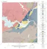
Geology of the Plata Verde Mine, Hudspeth County, Texas | 1982 | Price, J.G. | Bureau of Economic Geology | |
|
Facies and stratigraphy of the San Andreas Formation, northern and northwestern shelves of the Midland basin, Texas and New Mexico | 1982 | The San Andres Formation on the Northern and Northwestern Shelves of the Midland Basin is a progradational stratigraphic unit consisting predominantly of carbonate facies. Lithofacies include dolomite, laminated anhydrite and dolomite, massive bedded anhydrite, limestone, salt, and red beds. |
Ramondetta, P.J., Guetzow, D.D., Dauzat, Rick, Merritt, R.M., Garza, John, Holman, Lee, Roques, Dominick | Bureau of Economic Geology |
|
Depositional framework, hydrostratigraphy, and uranium mineralization of the Oakville Sandstone (Miocene), Texas coastal plain | 1982 | The Oakville Sandstone (Miocene) of the Texas Coastal Plain comprises a major sand-rich fluvial system composed of deposits of several major and minor rivers that originated within Texas and surrounding states. |
Galloway, W.E., Henry, C.D., Smith, G.E. | Bureau of Economic Geology |
|
Environmental geology of the Yegua - Jackson lignite belt, southeast Texas | 1982 | Environmental geologic maps of the Texas lignite belt were prepared in response to renewed production of lignite in Texas and enactment of Federal and State laws governing coal and lignite surface mining. |
Jackson, M.L.W., Garner, L.E., Sharpe, R.D. | Bureau of Economic Geology |
|
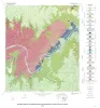
Geology of the Marble Falls quadrangle, Burnet and Llano Counties, Texas. | 1982 | Barnes, V.E. | Bureau of Economic Geology | |
|
The Mineral Industry of Texas in 1982 | 1982 | Ward, A.E. | Bureau of Economic Geology | |
|
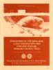
Formation of the Wink Sink, a salt dissolution and collapse feature, Winkler County, Texas | 1982 | The Wink Sink in Winkler County, Texas, formed on June 3, 1980. Within 24 hours it had expanded to a maximum width of 360 ft (110 m). On June 5, 1980, maximum depth of the sinkhole was 110 ft (34 m), and volume about 5.6 million ft3 (158,600 m3). |
Baumgardner, R.W., Jr., Hoadley, A.D., Goldstein, A.G., Hummel, Gary, Young, D'nese, Sandstrom, M.A., Forman, J.L. | Bureau of Economic Geology |
|
Geology of the Pedernales Falls quadrangle, Blanco County, Texas | 1982 | Barnes, V.E. | Bureau of Economic Geology | |
|
Coastal evaporite and tidal-flat sediments of the upper Clear Fork and Glorieta Formations, Texas panhandle | 1982 | Red beds, evaporites, and carbonates of the upper Clear Fork and Glorieta Formations (Permian) of the Texas Panhandle form an association of facies deposited in nearshore and supratidal environments along an arid coastline. |
Presley, M.W., McGillis, K.A., Mikan, F.M., Gray, C.A. | Bureau of Economic Geology |
|
Geology of the Spicewood Quadrangle, Blanco, Burnet, and Travis Counties, Texas | 1982 | Barnes, V.E. | Bureau of Economic Geology |