Bureau of Economic Geology Publications
| Title | Publication Year Sort ascending | Abstract | Author | Publisher | |
|---|---|---|---|---|---|
|
Clastic Depositional Systems: A Genetic Approach to Facies Analysis - An Annotated Outline and Bibliography | 1984 | Fisher, W.L., Brown, L.F., Jr. | Bureau of Economic Geology | |
|
Oil Accumulation, Production Characteristics, and Targets for Additional Recovery in Major Oil Reservoirs of Texas | 1984 | Characterization of 500 of the largest Texas oil reservoirs permits grouping into plays of similar geology and common engineering and production attributes. |
Tyler, Noel, Galloway, W.E., Garrett, C.M., Jr., Ewing, T.E. | Bureau of Economic Geology |
|
Observations from the east Texas seismic network (June 1981 - August 1982) | 1984 | Several microearthquake recording stations were operated as a network in the East Texas Basin beginning in June 1981. At least six certain and two probable earthquakes as well as hundreds of events of undetermined origin were recorded through August 1982. |
Pennington, W.D., Carlson, S.M. | Bureau of Economic Geology |
|
Styles of deformation in Permian strata, Texas panhandle | 1984 | Permian strata in the Texas Panhandle exhibit a variety of deformation styles that are attributed to tectonic stresses as well as to collapse caused by evaporite dissolution. At Caprock Canyons State Park, deformation structures above salt dissolution zones include veins, faults, and folds. |
Collins, E.W. | Bureau of Economic Geology |
|
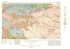
Geologic Atlas of Texas, Dalhart sheet | 1984 | Oversize color geologic map that depicts the surface geology of Dallam County and parts of Sherman, Moore, and Hartley Counties, Texas. The 6-page booklet indicates geologic formations, abbreviations, and ages. |
Barnes, V.E., Eifler, G.K., Fay, R.O., Trauger, F.D., Lappala E.G., Johnson, G.S., Hood, H.C., Stagges, D | Bureau of Economic Geology |
|
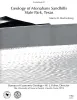
Geology of Monahans Sandhills State Park, Texas | 1984 | Sand dunes at Monahans Sandhills State Park display a variety of dune forms that develop under a unique trimodal wind regime. Large expanses of unvegetated sand form akle dunes having reversing slip faces. |
Machenberg, M.D. | Bureau of Economic Geology |
|
Cotton Valley (Upper Jurassic) and Hosston (Lower Cretaceous) depositional systems and their influence on salt tectonics in the east Texas basin | 1984 | Correct interpretation of the effect of basin infilling on salt mobilization is critical to understanding salt dome growth and stability. The size of salt structures in the East Texas Basin is determined by the original thickness of the underlying Louann Salt (Middle Jurassic). |
McGowen, M.K., Harris, D.W. | Bureau of Economic Geology |
|
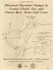
Historical shoreline changes in Corpus Christi, Oso, and Nueces Bays, Texas Gulf coast | 1984 | Changes in the position and stability of shorelines around Corpus Christi, Oso, and Nueces Bays, Texas Gulf Coast, were documented using historical-monitoring techniques. |
Morton, R.A., Paine, J.G., Robinson, D.E. | Bureau of Economic Geology |
|
Depositional systems and structural controls of Hackberry Sandstone reservoirs in southeast Texas | 1984 | Deep-water sandstones of the Oligocene-age Hackberry unit of the Frio Formation contain significant quantities of oil and gas and remain potentially one of the most productive exploration targets in southeast Texas. |
Ewing, T.E., Reed, R.S. | Bureau of Economic Geology |
|
Atlas of major Texas oil reservoirs | 1983 | The search for oil, its development, production, and marketing have, for the better part of a century, been a fundamental part of the Texas economy. The history of Texas oil finders, from the self-educated wildcatter to the highly trained explorationist, is a part of Texas lore. |
Galloway, W.E., Ewing, T.E., Garrett, C.M., Jr., Tyler, Noel, Bebout, D.G., Ambrose, W.A., Meador, Karen, Woodward, M.T. | Bureau of Economic Geology |