Bureau of Economic Geology Publications
| Title | Publication Year Sort ascending | Abstract | Author | Publisher | |
|---|---|---|---|---|---|
|
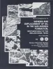
Formation of the Wink Sink, a salt dissolution and collapse feature, Winkler County, Texas | 1982 | The Wink Sink in Winkler County, Texas, formed on June 3, 1980. Within 24 hours it had expanded to a maximum width of 360 ft (110 m). On June 5, 1980, maximum depth of the sinkhole was 110 ft (34 m), and volume about 5.6 million ft3 (158,600 m3). |
Baumgardner, R.W., Jr., Hoadley, A.D., Goldstein, A.G., Hummel, Gary, Young, D'nese, Sandstrom, M.A., Forman, J.L. | Bureau of Economic Geology |
|
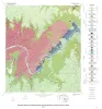
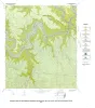
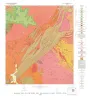
Geology of the Pedernales Falls quadrangle, Blanco County, Texas | 1982 | Barnes, V.E. | Bureau of Economic Geology | |
|
Coastal evaporite and tidal-flat sediments of the upper Clear Fork and Glorieta Formations, Texas panhandle | 1982 | Red beds, evaporites, and carbonates of the upper Clear Fork and Glorieta Formations (Permian) of the Texas Panhandle form an association of facies deposited in nearshore and supratidal environments along an arid coastline. |
Presley, M.W., McGillis, K.A., Mikan, F.M., Gray, C.A. | Bureau of Economic Geology |
|
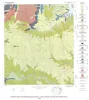
Geology of the Spicewood Quadrangle, Blanco, Burnet, and Travis Counties, Texas | 1982 | Barnes, V.E. | Bureau of Economic Geology | |
|
Genesis and emplacement of oil in the San Andreas Formation, northern shelf of the Midland basin, Texas | 1982 | San Andres oil constitutes more than 80 percent of the total production from the Northern Shelf of the Midland Basin, Texas. |
Ramondetta, P.J. | Bureau of Economic Geology |
|
Geology of the Hammetts Crossing Quadrangle, Blanco, Hays, and Travis Counties, Texas | 1982 | Barnes, V.E. | Bureau of Economic Geology | |
|
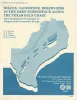
Wilcox Sandstone reservoirs in the deep subsurface along the Texas Gulf Coast -- their potential for production of geopressured geothermal energy | 1982 | Regional studies of the lower Eocene Wilcox Group in Texas were conducted to assess the potential for producing heat energy and solution methane from geopressured fluids in the deep-subsurface growth-faulted zone. |
Bebout, D.G., Weise, B.R., Gregory, A.R., Edwards, M.B. | Bureau of Economic Geology |
|
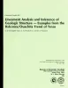
Lineament analysis and inference of geologic structure -- examples from the Balcones/Ouachita trend of Texas | 1982 | Lineaments perceived in remotely sensed images are reliable indicators of geologic structure. |
Caran, S.C., Woodruff, C.M., Jr., Thompson, E.J. | Bureau of Economic Geology |
|
Geology of the Purdy Hill quadrangle, Mason County, Texas | 1982 | Mutis-Duplat, Emilio | Bureau of Economic Geology | |
|
Geochemistry of ground water in the Miocene Oakville Sandstone -- a major aquifer and uranium host of the Texas coastal plain | 1982 | The Oakville Sandstone is a major aquifer and a major host of uranium deposits in the Texas Coastal Plain. |
Henry, C.D., Galloway, W.E., Smith, G.E., Ho, C.L., Morton, J.P., Gluck, J.K. | Bureau of Economic Geology |