Bureau of Economic Geology Publications
| Title | Publication Year Sort ascending | Abstract | Author | Publisher | |
|---|---|---|---|---|---|
|
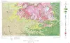
Geologic Atlas of Texas, Llano sheet | 1981 | Geologic map that depicts the surface geology of Mason, Llano, and Gillespie Counties and parts of Menard, Kimble, San Saba, McCulloch, Edwards, Real, Kerr, Kendall, Blanco, Hays, Travis, Williamson, and Burnet Counties, Texas. |
Barnes, V.E., Shell Oil Co., Boyer, R.E., Clabaugh, S.E., Baker, E.T. | Bureau of Economic Geology |
|
Depositional and diagenetic history of the Sligo and Hosston Formations(Lower Cretaceous) in south Texas | 1981 | The Sligo and Hosston Formations of Aptian age occur over thousands of square miles in the subsurface of South Texas. |
Bebout, D.G., Budd, D.A., Schatzinger, R.A. | Bureau of Economic Geology |
|
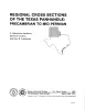
Regional cross sections of the Texas panhandle: Precambrian to mid-Permian | 1981 | The Texas Panhandle traditionally has been an important source of mineral resources, especially petroleum, and resources will continue to contribute heavily to the economy of the area. The seven cross sections of this report synthesize the subsurface geology of the region. |
Handford, C.R., Dutton, S.P., Fredericks, P.E. | Bureau of Economic Geology |
|
A preliminary assessment of the geologic setting, hydrology, and geochemistry of the Hueco Tanks geothermal area, Texas and New Mexico | 1981 | The Hueco Tanks geothermal area contains five known but now inactive hot wells (50° to 71°C). The area trends north-south along the east side of Tularosa-Hueco Bolson astride the Texas-New Mexico border approximately 40 km northeast of El Paso. |
Henry, C.D., Gluck, J.K. | Bureau of Economic Geology |
|
Statistical analysis of lineaments and their relation to fracturing, faulting, and halokinesis in the east Texas basin | 1981 | Lineament analysis is part of a broad spectrum of structural studies employed to determine the tectonic stability of the East Texas Basin. Such information is necessary to assess the suitability of East Texas salt domes as possible repository sites for the storage of high-level nuclear wastes. |
Dix, O.R., Jackson, M.P.A. | Bureau of Economic Geology |
|
History of the Bureau of Economic Geology, 1909-1960 | 1981 | The Bureau of Economic Geology—this bureaucratic title belies the essence of this organization: an ongoing group of professionals with a definite personality. |
Ferguson, W.K. | Bureau of Economic Geology |

|
Structural cross sections, Tertiary formations, Texas Gulf Coast | 1981 | The publication comprises 24 structural dip cross sections, spaced 15 to 20 mi apart along the Texas coast, and 4 structural strike cross sections. Dip sections extend from near the Wilcox outcrop to the coastline. |
Dodge, M.M., Posey, J.S. | Bureau of Economic Geology |
|
Calderas and mineralization: volcanic geology and mineralization in the Chinati caldera complex, Trans-Pecos Texas | 1981 | This report describes preliminary results of an ongoing study of the volcanic stratigraphy, caldera activity, and known and potential mineralization of the Chinati Mountains area of Trans-Pecos Texas. Many ore deposits are spatially associated with calderas and other volcanic centers. |
Duex, T.W., Henry, C.D. | Bureau of Economic Geology |
|
The aluminum industry of Texas | 1981 | Barron, Terry | Bureau of Economic Geology | |
|
Factors controlling reservoir quality in Tertiary sandstones and their significance to geopressured geothermal production | 1981 | Variable intensity of diagenesis is the factor primarily responsible for contrasting regional reservoir quality of Tertiary sandstones from the upper and lower Texas coast. |
Loucks, R.G., Richmann, D.L., Milliken, K.L., Elliot, M.M., Forman, J.L., Jirik, L.A., McCall, C.L., Suter, J.R. | Bureau of Economic Geology |