Bureau of Economic Geology Publications
| Title | Publication Year Sort ascending | Abstract | Author | Publisher | |
|---|---|---|---|---|---|
|
Investigation of underpressuring in the deep-basin brine aquifer, Palo Duro basin, Texas | 1985 | Although plots of pressure versus depth are useful for understanding the hydrodynamics of ground-water systems, they can be difficult to interpret. |
Orr, E.D., Kreitler, C.W., Senger, R.K. | Bureau of Economic Geology |
|
Depositional history, facies analysis, and production characteristics of hydrocarbon-bearing sediments, offshore Texas | 1985 | Large areas of offshore Texas remain unexplored even though sedimentary facies and structural traps favor the generation and accumulation of hydrocarbons. |
Morton, R.A., Jirik, L.A., Foote, R.Q. | Bureau of Economic Geology |
|
Abandoned oil fields of the Texas Gulf coast and the east Texas basin | 1985 | One nonconventional target for increased oil recovery in Texas is oil that remains in abandoned reservoirs, defined as reservoirs that produced no oil or gas in 1977 and 1982. |
Dutton, S.P., Garrett, C.M., Jr. | Bureau of Economic Geology |
|
Amount and nature of occluded water in bedded salt, Palo Duro basin, Texas | 1985 | Bedded salt of the Permian San Andres Formation, Palo Duro Basin, Texas, is under consideration for the isolation of high-level nuclear waste. |
Fisher, R.S. | Bureau of Economic Geology |
|
Beach and vegetation-line changes at Galveston Island, Texas: erosion, deposition, and recovery from Hurricane Alicia | 1985 | On August 18, 1983, Hurricane Alicia crossed the upper Texas Gulf Coast and caused extensive property damage, especially along West Beach of Galveston Island. |
Morton, R.A., Paine, J.G. | Bureau of Economic Geology |
|
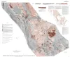
Tectonic map of the Basin and Range Province of Texas and adjacent Mexico | 1985 | Henry, C.D., Price, J.G., Gluck, J.K., Bockoven, N.T. | Bureau of Economic Geology | |
|
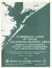
Submerged lands of Texas, Galveston - Houston area: sediments, geochemistry, benthic macroinvertebrates, and associated wetlands | 1985 | The State-owned submerged lands of Texas encompass almost 6,000 mi2 (15,540 km2). They lie below waters of the bay-estuary-lagoon system and the Gulf of Mexico and extend 10.3 mi (16.6 km) seaward from the Gulf shoreline (fig. 1). |
White, W.A., Calnan, T.R., Morton, R.A., Kimble, R.S., Littleton, T.G., McGowen, J.H., Nance, H.S., Schmedes, K.E. | Bureau of Economic Geology |
|
Natural Strain in Diapiric and Glacial Rock Salt, with Emphasis on Oakwood Dome, East Texas | 1985 | Structural styles in the gravity-driven, ductile flow processes of glaciers and diapirs are analyzed. When dampened by rainfall, salt glaciers flow rapidly under minute differential stress. |
Jackson, M.P.A. | Bureau of Economic Geology |
|
The Wilcox Group and Carrizo Sand (Paleogene) in east-central Texas: depositional systems and deep-basin lignite | 1985 | Ayers Jr., W.B., Lewis, A.H., Bissett, F.H., Mazza, D.B., Prouty, D.A., Reutter, D.C., Sutley, A.M. | Bureau of Economic Geology | |
|
Reservoir facies architecture in a microtidal barrier system -- Frio Formation, Texas Gulf Coast | 1985 | Sandstone reservoirs deposited in microtidal barrier systems contain large oil and gas reserves in several Gulf Coast Basin plays. |
Galloway, W.E., Cheng, E.S. | Bureau of Economic Geology |