Bureau of Economic Geology Publications
| Title | Publication Year Sort ascending | Abstract | Author | Publisher | |
|---|---|---|---|---|---|
|
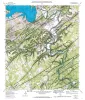
Geologic map of the Sattler quadrangle, Texas | 1991 | Collins, E.W., Baumgardner, R.W., Jr., Raney, J.A. | Bureau of Economic Geology | |
|
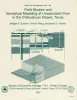
Field studies and numerical modeling of unsaturated flow in the Chihuahuan Desert, Texas | 1991 | Field studies and numerical modeling were used to evaluate hydraulic controls on unsaturated flow in the Chihuahuan Desert of Texas. These studies were part of a program to characterize a site for a proposed low-level radioactive waste disposal facility. |
Scanlon, B.R., Wang, F.P., Richter, B.C. | Bureau of Economic Geology |
|
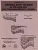
Structural history and origin of the Sabine Arch, east Texas and northwest Louisiana | 1991 | The Sabine Arch is a large (1 2,000 mi2 [31,000 km2]), low-amplitude anticline centered on the Texas-Louisiana border. |
Jackson, M.L.W., Laubach, S.E. | Bureau of Economic Geology |
|
Plio-Pleistocene depositional sequences of the southeastern Texas continental shelf and slope: geologic framework, sedimentary facies, and hydrocarbon distribution | 1991 | Plio-Pleistocene strata of offshore Texas having hydrocarbon exploration potential are restricted to the southeastern continental shelf and upper continental slope. This thick wedge of nearshore and deep-marine sediments firms the west margin of a late Neogene and Quaternary depocenter. |
Morton, R.A., Sams, R.H., Jirik, L.A., Banta, N.J., Single, R.S. | Bureau of Economic Geology |
|
A Glossary of Salt Tectonics | 1991 | In response to a need for a concise presentation of new terms and concepts in salt tectonics, we have compiled a glossary that focuses on ideas developed during the 1980's. |
Jackson, M.P.A., Talbot, C.J. | Bureau of Economic Geology |
|
Stratigraphic analysis of the Upper Devonian Woodford Formation, Permian Basin, West Texas and southeastern New Mexico | 1991 | The Upper Devonian Woodford Formation is an organic-rich petroleum source rock that extends throughout West Texas and southeastern New Mexico and currently is generating oil or gas in the subsurface. |
Comer, J.B. | Bureau of Economic Geology |
|
Regional hydrodynamics of variable-density flow systems, Palo Duro basin, Texas | 1991 | In mature sedimentary basins, where mechanical compaction is negligible, the hydrodynamics is typically described by steady-state flow driven by potential energy represented by the water table, which generally follows the topography. |
Senger, R.K. | Bureau of Economic Geology |
|
Reservoir Modeling of Restricted Platform Carbonates: Geologic/Geostatistical Characterization of Interwell-Scale Reservoir Heterogeneity, Dune Field, Crane County, Texas | 1990 | Petroleum reservoirs typically yield only a fraction of the oil initially in place because geologic heterogeneity causes incomplete drainage of oil. |
Fogg, G.E., Lucia, F.J. | Bureau of Economic Geology |
|
Identification of sources and mechanisms of salt-water pollution affecting ground-water quality: a case study, West Texas | 1990 | Occurrences of ground-water and soil salinization are numerous in the Concho River watershed and its confluence with the Colorado River in West Texas and in other semiarid regions of Texas and the United States. |
Richter, B.C., Dutton, A.R., Kreitler, C.W. | Bureau of Economic Geology |
|
Hydrogeology of the northern segment of the Edwards aquifer, Austin region | 1990 | Geologic mapping and fracture analysis of the Lower Cretaceous Edwards aquifer strata near Georgetown and Round Rock, Texas, were performed to provide a better understanding of the geologic framework of the Balcones Fault Zone and to provide information for assessing ground-water flow characteris |
Senger, R.K., Collins, E.W., Kreitler, C.W. | Bureau of Economic Geology |