Bureau of Economic Geology Publications
| Title | Publication Year Sort ascending | Abstract | Author | Publisher | |
|---|---|---|---|---|---|
|
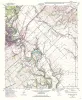
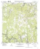
Geologic map of the New Braunfels East quadrangle, Texas | 1993 | Collins, E.W. | Bureau of Economic Geology | |
|
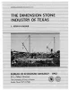
The dimension stone industry of Texas | 1992 | Garner, L.E. | Bureau of Economic Geology | |
|
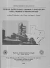
Texas Portland cement industry and cement resources | 1992 | McBride, M.W., Patty, T.S., Sharpe, R.D. | Bureau of Economic Geology | |
|
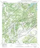
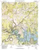
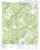
Geologic map of the Smithson Valley quadrangle, Texas | 1992 | Collins, E.W. | Bureau of Economic Geology | |
|
Geologic map of the Spring Branch Quadrangle, Texas | 1992 | Collins, E.W. | Bureau of Economic Geology | |
|
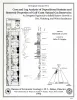
Core and Log Analyses of Depositional Systems and Reservoir Properties ... in Frio, Vicksburg, and Wilcox Sandstones | 1992 | The Gas Research Institute, U.S. Department of Energy, and the State of Texas cooperated in joint-venture research to evaluate the infield reserve growth potential of mature gas fields containing conventional reservoirs. |
Levey, R.A., Grigsby, J.D. | Bureau of Economic Geology |
|
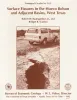
Surface fissures in the Hueco Bolson and adjacent basins, West Texas | 1992 | Surface fissures have been observed in many desert basins in the western United States. These surface-collapse features are usually discovered after a normally dry surface has been covered with water, either by runoff from intense rainfall, by flooding, or by irrigation. |
Baumgardner, R.W., Jr., Scanlon, B.R. | Bureau of Economic Geology |
|
Geologic map of the Fischer quadrangle, Texas | 1992 | Collins, E.W. | Bureau of Economic Geology | |
|
Geologic map of the Anhalt quadrangle, Texas | 1992 | Collins, E.W. | Bureau of Economic Geology | |
|
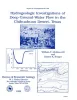
Hydrogeologic investigations of deep ground-water flow in the Chihuahuan Desert, Texas | 1992 | Regional and local hydrologic investigations were conducted in Trans-Pecos Texas as part of a study to evaluate potential sites for a low-level radioactive waste repository. |
Mullican, W.F., Senger, R.K. | Bureau of Economic Geology |