Bureau of Economic Geology Publications
| Title | Publication Year Sort ascending | Abstract | Author | Publisher | |
|---|---|---|---|---|---|
|
Hydrogeologic investigations of deep ground-water flow in the Chihuahuan Desert, Texas | 1992 | Regional and local hydrologic investigations were conducted in Trans-Pecos Texas as part of a study to evaluate potential sites for a low-level radioactive waste repository. |
Mullican, W.F., Senger, R.K. | Bureau of Economic Geology |
|
Atlas of Major Central and Eastern Gulf Coast Gas Reservoirs | 1992 | The Atlas of Major Central and Eastern Gulf Coast Gas Reservoirs is the second in a series compiling geologic and engineering data on natural gas reservoirs in the major gas-producing regions of the United States. |
Bebout, D.G., White, W.A., Garrett, C.M., Jr., Hentz, T.F. | Bureau of Economic Geology |
|
Geology of the Infiernito caldera and magmatic evolution of the Chinati Mountains, Trans-Pecos Texas | 1992 | The 37-Ma-old Infiernito caldera of the northern Chinati Mountains is a major eruptive center of the mid-Tertiary volcanic field of Trans-Pecos Texas. Volcanism in the Chinati Mountains began with eruption of a sequence of rhyolitic to trachytic lavas, the precollapse lavas. |
Henry, C.D., Price, J.G., Duex, T.W., James, E.W. | Bureau of Economic Geology |
|
Environmental and applied tracers as indicators of liquid and vapor transport in the Chihuahuan Desert, Texas | 1992 | Chemical and physical approaches are used to study unsaturated flow; however, few studies include an in-depth analysis of data from both approaches. |
Scanlon, B.R. | Bureau of Economic Geology |
|
Characterization of a Karsted, High-Energy, Ramp-Margin Carbonate Reservoir: Taylor-Link West San Andres Unit, Pecos County | 1992 | A waterflood was begun in 1985 in Taylor-Link West San Andres unit (10 million barrels cumulative production) on the south margin of the Central Basin Platform to capture a remaining mobile oil target estimated at 20 million barrels. |
Lucia, F.J., Kerans, Charles, Vander Stoep, G.W. | Bureau of Economic Geology |
|
The Rise and Fall of Diapirs During Thin-Skinned Extension | 1992 | Grabens overlying diapirs have previously been ascribed to intrusion, withdrawal, or dissolution of salt. We propose, however, that many grabens or half grabens above diapirs form by regional thin-skinned extension of a brittle overburden. |
Vendeville, B.C., Jackson, M.P.A. | Bureau of Economic Geology |
|
Technology Transfer Needs and Requirements for Texas Independent Oil and Gas Producers: Increasing Oil and Gas Discovery Efficiency through Advanced Technology Applications | 1992 | Texas has large resources of oil and natural gas that remain unrecovered. |
Bureau of Economic Geology | |
|
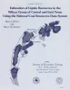
Plio-Pleistocene genetic sequences of the southwestern Louisiana continental shelf and slope: geologic framework, sedimentary facies, and hydrocarbon distribution | 1992 | The Plio-Pleistocene hydrocarbon fairway of offshore western Louisiana is restricted to the outer continental shelf and upper continental slope where a thick wedge of nearshore and deep-marine sediments was deposited. |
Morton, R.A., Ayers Jr., W.B. | Bureau of Economic Geology |
|
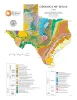
Geology of Texas | 1992 | University of Texas at Austin, Bureau of Economic Geology | Bureau of Economic Geology | |
|
Estimation of lignite resources in the Wilcox Group of central and east Texas using the National Coal Resources Data System | 1991 | Since 1979, the U.S. Geological Survey (USGS) has funded cooperative programs with coal-bearing states in an effort to provide current U.S. coal resource estimates that are calculated by uniform, computerized methods. |
Tewalt, S.J., Jackson, M.L.W. | Bureau of Economic Geology |