|
The Big Bend of the Rio Grande -- a guide to the rocks, landscape, geologic history, and settlers of the area of Big Bend National Park |
Maxwell, R.A. |
1968 |
Guidebook |
|
Igneous Geology of the Central Davis Mountains, Jeff Davis County, Texas |
Anderson, J.E. |
1968 |
Geologic Quadrangle Map |
|
New Brazilian Forms of Hyla |
|
1968 |
Texas Memorial Museum |
|
Taxonomy of the Neotropical Hylidae |
|
1968 |
Texas Memorial Museum |
|
South Texas Uranium |
|
1968 |
Corpus Christi Geological Society |
|
Geographic Variation in Brazilian Species of Hyla |
|
1968 |
Texas Memorial Museum |
|
Bonfire Shelter: A Stratified Bison Kill Site, Val Verde County, Texas |
|
1968 |
Texas Memorial Museum |
|
Remarks on the Geographical Distribution and Phyletic Trends of South American Toads |
|
1968 |
Texas Memorial Museum |
![Texas Mining Laws Pertaining to State Public Lands [as of 1968]](/files/styles/thumbnail/public/publication_covers/MM0033.jpg.webp?itok=yjiLWO-3)
|
Texas Mining Laws Pertaining to State Public Lands [as of 1968] |
Leach, C.H. |
1968 |
Miscellaneous Map |
|
Falcon Dam and the Lost Towns of Zapata |
|
1968 |
Texas Memorial Museum |
|
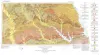
Geologic Atlas of Texas, Houston sheet (revised 1982) |
Barnes, V.E., Aronow, Saul, LeBlanc, R.J., Evans, F.G., Hinds, G.W., Holland, W.C., Van Siclen, D.C., Macon, J.W., Hartmann, B. |
1968 |
Geologic Atlas of Texas |
|
Glen Rose cycles and facies, Paluxey River Valley, Somervell County, Texas |
Nagle, J.S. |
1968 |
Geological Circular |
|
Geologic Atlas of Texas, Lubbock sheet (revised 1993) |
Eifler, G.K., Frye, J.C., Leonard, A.B., Hentz, T.F., Barnes, V.E. |
1967 |
Geologic Atlas of Texas |
|
The Mineral Industry of Texas in 1966 |
Netzeband, F.F., Girard, R.M. |
1967 |
Mineral Resource Circular |
|
Lower Cretaceous sands of Texas: stratigraphy and resources |
Fisher, W.L., Rodda, P.U. |
1967 |
Report of Investigations |
|
Sand resources of Texas gulf coast |
Garner, L.E. |
1967 |
Report of Investigations |
|
Geologic Atlas of Texas, Palestine sheet (revised 1993) |
Barnes, V.E., Humble Oil and Refining Co., Shell Oil Co., Pan American Petroleum Corp., Mobil Oil Co., Wright, A.C., McCallum, H.D., Wendlandt, E.A., Burford, S.O., Shelby, T.H., Gibson, D.T., Eaton, R.W., Shelby, C.A., Pieper, M.K. |
1967 |
Geologic Atlas of Texas |
|
Geology of the Cave Creek School Quadrangle, Gillespie County, Texas |
Barnes, V.E. |
1967 |
Geologic Quadrangle Map |
|
Late Cambrian and Early Ordovician faunas from the Wilberns Formation of central Texas |
Winston, Don, Nicholls, Harry |
1967 |
Report of Investigations |
|
GCAGS Transactions Volume 17 (1967) San Antonio |
|
1967 |
Gulf Coast Association of Geological Societies |