Publications in Hudspeth
| Title | Publication Year Sort ascending | Abstract | Author | Series | Publisher | |
|---|---|---|---|---|---|---|
| |
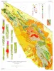
Geologic Atlas of Texas, Van Horn-El Paso sheet (revised 1983) | 1968 | Geologic map that depicts the surface geology of El Paso County and parts of Hudspeth. Jeff Davis, and Culberson Counties, Texas. The 12-page booklet indicates geologic formations, abbreviations, and ages. Published in honor of E. |
Barnes, V.E., Shell Oil Co., Cities Service Petroleum Co., Dietrich, J.W., Owen, D.E., Shelby, C.A., Macon, J.W., Bridges, L.W. | Geologic Atlas of Texas | Bureau of Economic Geology |
|
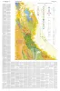
Geology of the Eagle Mountains and Vicinity, Hudspeth County, Texas | 1963 | Eagle Mountains and vicinity include three physiographically distinct but stratigraphically and structurally related sub-units: a central, topographically high mesa, Eagle Mountains; a much lower northwestward extension, Devil Ridge; and a south-southeastward extension, Indio Mountains. |
Underwood, J.R. | Geologic Quadrangle Map | Bureau of Economic Geology |
|
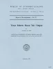
Geology of Van Horn Mountains, Texas | 1959 | About 10 miles south of Van Horn, Texas, the Van Horn Mountains rise abruptly above an intermontane plain and extend southward to the Sierra Vieja. The area lies primarily in the southwestern part of Culberson County but extends into Hudspeth and Jeff Davis counties. |
Twiss, P.C. | Geologic Quadrangle Map | Bureau of Economic Geology |
|
Texas Miners Boost Talc Output | 1958 | Texas' Hudspeth County talc mining, begun in 1952 when Southwestern Talc Corp. carried out pioneer exploratory operations, has expanded during the last five years and can today claim six active operations. These Include (1) Southwestern Talc Corp., Llano, Texas, (2) West Texas Talc Corp. |
Flawn, P.T. | Report of Investigations | Bureau of Economic Geology |
|
Geology and Mineral Deposits of Pre-Cambrian Rocks of the Van Horn Area, Texas | 1953 | King, P.B., Flawn, P.T. | UT Publication | ||
|
The Hazel copper-silver mine, Culberson County, Texas | 1952 | The Hazel mine is one of the oldest mines in Texas and has been the largest copper-producing property in the State. |
Flawn, P.T. | Report of Investigations | Bureau of Economic Geology |
|
Pegmatites of the Van Horn Mountains, Texas | 1951 | Zoned and unzoned perthite-quartz-plagioclase-muscovite pegmatites in the form of tabular bodies, irregular bodies with tabular branches, irregular masses, elongate lenses, lit-par-lit zones, and small augen and stringers are distributed throughout the Precambrian metasedimentary rocks of the Mic |
Flawn, P.T. | Report of Investigations | Bureau of Economic Geology |
|
Progress report on copper investigations | 1943 | Evans, G.L. | Mineral Resource Circular | Bureau of Economic Geology | |
|
Fluorspar deposits in the Eagle Mountains of Hudspeth County, Texas | 1943 | Evans, G.L. | Mineral Resource Circular | Bureau of Economic Geology | |
|
Exploratory geology of a part of southwestern Trans-Pecos Texas | 1927 | Baker, C.L. | UT Bulletin | Bureau of Economic Geology |