Publications in Hudspeth
| Title | Publication Year Sort ascending | Abstract | Author | Series | Publisher | |
|---|---|---|---|---|---|---|
|
Hydrogeologic investigations of deep ground-water flow in the Chihuahuan Desert, Texas | 1992 | Regional and local hydrologic investigations were conducted in Trans-Pecos Texas as part of a study to evaluate potential sites for a low-level radioactive waste repository. |
Mullican, W.F., Senger, R.K. | Report of Investigations | Bureau of Economic Geology |
|
Environmental and applied tracers as indicators of liquid and vapor transport in the Chihuahuan Desert, Texas | 1992 | Chemical and physical approaches are used to study unsaturated flow; however, few studies include an in-depth analysis of data from both approaches. |
Scanlon, B.R. | Report of Investigations | Bureau of Economic Geology |
|
Tertiary and Quaternary structure and paleotectonics of the Hueco Basin, Trans-Pecos Texas and Chihuahua, Mexico | 1991 | The Hueco Basin of Trans-Pecos Texas, which formed in response to Cenozoic extensional tectonism, lies within the southern Rio Grande rift near the poorly defined boundary between the rift and the southern Basin and Range province. |
Collins, E.W., Raney, J.A. | Geological Circular | Bureau of Economic Geology |
|
Arid basin depositional systems and paleosols: Fort Hancock and Camp Rice Formations (Pliocene-Pleistocene), Hueco Bolson, West Texas and adjacent Mexico | 1991 | The Hueco Bolson is a segment of the Rio Grande Rift that formed as a result of late Tertiary Basin and Range deformation. The upper Tertiary Fort Hancock Formation and the upper Tertiary-Quaternary Camp Rice Formation compose the basin fill except in the deepest (western) parts of the bolson. |
Gustavson, T.C. | Report of Investigations | Bureau of Economic Geology |

|
Field studies and numerical modeling of unsaturated flow in the Chihuahuan Desert, Texas | 1991 | Field studies and numerical modeling were used to evaluate hydraulic controls on unsaturated flow in the Chihuahuan Desert of Texas. These studies were part of a program to characterize a site for a proposed low-level radioactive waste disposal facility. |
Scanlon, B.R., Wang, F.P., Richter, B.C. | Report of Investigations | Bureau of Economic Geology |
|
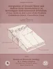
Neotectonic history and structural style of the Campo Grande fault, Hueco basin, Trans-Pecos Texas | 1990 | The Hueco Basin of Trans-Pecos Texas and Chihuahua, Mexico, formed in response to Basin and Range extensional tectonism that began about 24 Ma ago and continues to the present. |
Collins, E.W., Raney, J.A. | Report of Investigations | Bureau of Economic Geology |
|
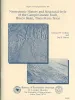
Integration of ground-water and vadose-zone geochemistry to investigate hydrochemical evolution: a case study in arid lands of the northern Chihuahuan Desert, Trans-Pecos Texas | 1990 | The hydrochemical history of ground water in the arid southeastern Hueco Bolson and southwestern Diablo Plateau was investigated by collecting soil-moisture samples from unsaturated siliciclastic bolson-fill sediments and groundwater samples from the Diablo Plateau aquifer, the Hueco Bolson silt |
Fisher, R.S., Mullican, W.F. | Geological Circular | Bureau of Economic Geology |
|
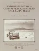
Hydrogeology of a gypsum playa, northern Salt Basin, Texas | 1986 | The northern Salt Basin in West Texas and New Mexico is a closed hydrologic system in which discharge of ground-water flow occurs in a series of playas, or salt flats. |
Boyd, F.M., Kreitler, C.W. | Report of Investigations | Bureau of Economic Geology |
|
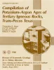
Compilation of potassium-argon ages of Tertiary igneous rocks, Trans-Pecos Texas | 1986 | This compilation of potassium-argon (K-Ar) ages of igneous rocks of the Tertiary volcanic field of Trans-Pecos Texas includes all published ages known to us as well as many unpublished results. |
Henry, C.D., McDowell, F.W., Price, J.G., Smyth, R.C. | Geological Circular | Bureau of Economic Geology |
|
Origin of silver-copper-lead deposits in red-bed sequences of Trans-Pecos Texas: Tertiary mineralization in Precambrian, Permian, and Cretaceous sandstones | 1985 | Silver deposits occur in Precambrian, Permian, and Cretaceous red-bed sequences near Van Horn, Texas. These deposits are geochemically similar and contain economically important quantities of silver, copper, and lead, as well as anomalously high amounts of arsenic, zinc, cadmium, and molybdenum. |
Price, J.G., Henry, C.D., Standen, A.R., Posey, J.S. | Report of Investigations | Bureau of Economic Geology |