Publications in Hudspeth
| Title | Publication Year Sort ascending | Abstract | Author | Series | Publisher | |
|---|---|---|---|---|---|---|
|
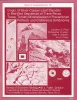
Origin of silver-copper-lead deposits in red-bed sequences of Trans-Pecos Texas: Tertiary mineralization in Precambrian, Permian, and Cretaceous sandstones | 1985 | Silver deposits occur in Precambrian, Permian, and Cretaceous red-bed sequences near Van Horn, Texas. These deposits are geochemically similar and contain economically important quantities of silver, copper, and lead, as well as anomalously high amounts of arsenic, zinc, cadmium, and molybdenum. |
Price, J.G., Henry, C.D., Standen, A.R., Posey, J.S. | Report of Investigations | Bureau of Economic Geology |
|
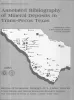
Annotated bibliography of mineral deposits in Trans-Pecos Texas | 1983 | Price, J.G., Henry, C.D., Standen, A.R. | Mineral Resource Circular | Bureau of Economic Geology | |
|
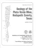
Geology of the Plata Verde Mine, Hudspeth County, Texas | 1982 | Price, J.G. | Mineral Resource Circular | Bureau of Economic Geology | |
|
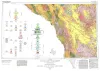
Geologic Atlas of Texas, Marfa sheet | 1979 | Geologic map that depicts surface geology of parts of Hudspeth, Culberson, Jeff Davis, and Presidio Counties, Texas. The 12-page explanatory booklet indicates geologic formations, abbreviations, and ages. |
Barnes, V.E., Twiss, P.C., Continental Oil Co., Cities Service Petroleum Co., Geophoto Services Inc., Norman, D.M., Sherrod, C.H., Pearson, B.T. | Geologic Atlas of Texas | Bureau of Economic Geology |
|
Geologic setting and geochemistry of thermal water and geothermal assessment, Trans-Pecos Texas | 1979 | Hot springs and wells in West Texas and adjacent Mexico are manifestations of active convective geothermal systems concentrated in a zone along the Rio Grande between the Quitman Mountains and Big Bend National Park. |
Henry, C.D. | Report of Investigations | Bureau of Economic Geology |
|
Tectonic map of the Rio Grande area, Trans-Pecos Texas and adjacent Mexico | 1977 | Henry, C.D., Bockoven, N.T. | Miscellaneous Map | Bureau of Economic Geology | |
|
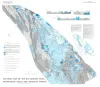
Asbestos in the Allamoore talc district, Hudspeth and Culberson Counties, Texas | 1973 | The Allamoore district of Hudspeth and Culberson counties, Texas, has become one of the most significant talc-producing areas of the United States. Exploitation of talc deposits in the district began in 1952 with a cumulative production of 120,000 tons through 1957 (Flawn, 1958). |
Rohrbacher, R.G. | Geological Circular | Bureau of Economic Geology |
|
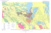
Gravity, magnetic, and generalized geologic map of the Van Horn -- Sierra Blanca Region, Trans-Pecos Texas | 1972 | The Van Horn-Sierra Blanca region lies athwart part of the boundary between two contrasting geologic provinces. The contrast between these two provinces, splendidly displayed by Holocene landforms in the present map area, has a history that dates back to at least Late Precambrian time. |
Wiley, M.A. | Geologic Quadrangle Map | Bureau of Economic Geology |
|
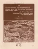
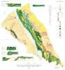
Van Horn Sandstone, West Texas: an alluvial fan model for mineral exploration | 1971 | The Van Horn Sandstone in southwestern Culberson and southeastern Hudspeth counties, Texas, was studied in cooperation with the U.S. |
McGowen, J.H., Groat, C.G. | Report of Investigations | Bureau of Economic Geology |
|
Geology of Southern Quitman Mountains, Hudspeth County, Texas | 1970 | The Quitman Mountains are part of a narrow mountain range that extends southeastward from near Sierra Blanca, Texas (85 miles southeast of El Paso, Texas), into northern Mexico. |
Jones, B.R., Reaser, D.F. | Geologic Quadrangle Map | Bureau of Economic Geology |