Publication Details
Geolocation:
Get the Publication
$19.00
Abstract/Description:
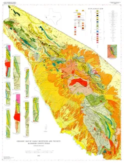
Eagle Mountains and vicinity include three physiographically distinct but stratigraphically and structurally related sub-units: a central, topographically high mesa, Eagle Mountains; a much lower northwestward extension, Devil Ridge; and a south-southeastward extension, Indio Mountains. These highlands, trending generally northwest to north-northwest, are surrounded by "bolsons" or inter- montane basins partly filled with alluvium. This area is an extension into southeastern Hudspeth County of the eastern part of a long, narrow, mountainous, structural belt that begins some 150 miles southeast near Ojinaga, Chihuahua, Mexico. The summit of Eagle Peak, 17 miles south- west of Van Horn, Culberson County, and 24 miles southeast of Sierra Blanca, Hudspeth County, is 7,496 feet above sea level, the highest point in Hudspeth County. The lowest point in the map area, the southeastern corner along the Rio Grande, is 3,150 feet above sea level; the maximum difference in elevation is about 4,350 feet. In the highlands, well-exposed rocks ranging in age from Precambrian to Re- cent include about 5,000 feet of meta- morphosed Precambrian sedimentary rocks, at least 1,000 feet of Permian lime- stone, and about 7,000 feet of marine Cretaceous strata, much of which is cov- ered by an early Tertiary volcanic rock sequence of flow breccia and fine-grained flow and pyroclastic rocks. Small intrusive bodies, mainly sills and dikes, crop out throughout the area; the highest part of the Eagles is a small, roughly semi- circular stock. The range is flanked by well-defined alluvial fans and terraces. The stratigraphy of the Cretaceous rocks was controlled by a fluctuating shoreline during the general advance of the Cretaceous sea north and east from the Chihuahua trough onto the Diablo Platform and the continental margin; structurally, the spatial relationships of the Cretaceous rocks were controlled by their location (1) on the southwest flank of the Van Horn uplift, (2) near the northwest end of the Laramide Chihuahua tectonic belt, and (3) near the eastern margin of the Basin-and-Range province.