
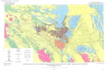
The Van Horn-Sierra Blanca region lies athwart part of the boundary between two contrasting geologic provinces. The contrast between these two provinces, splendidly displayed by Holocene landforms in the present map area, has a history that dates back to at least Late Precambrian time. This remarkable contrast led R. T. Hill (1902) to suggest the possibility of a transcontinental fracture zone passing near Van Horn and along the boundary of the provinces.
The Texas Coastal Zone is marked by diversity in geography, resources, climate, and industry. It is richly andowed with extensive petroleum reserves, sulfur and salt, deep-water ports, intracoastal waterways, mild climate, good water supplies, abundant wildlife, commercial fishing resources, unusual recreational potential, and large tracts of uncrowded land in close proximity to major population centers.
The West Chinati stock, well exposed in San Antonio Canyon and immediately westward on slopes of the southwestern part of the Chinati Mountains, Presidio County, Texas, is a large stocklike body of porphyritic hornblende granite cut by numerous dikes and irregular-shaped plutons of rhyolite, rhyolite porphyry, microgranite, trachyte porphyry, diorite, and igneous breccia.Fissure veins developed in wide and long sheeted zones which strike E-W and N. 50" E.
This Guidebook represents an updating of Bureau of Economic Geology Guidebook No. 5, Field Excursion-Geology of Llano Region and Austin Area. It also represents a modification of Geology of the Llano Region and Austin Area, Texas, published by the Shreveport Geological Society in 1971.