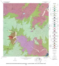
Comparison of Environmental Geology maps, from the Environmental Geologic Atlas of the Texas Coastal Zone, with aerial photographs taken in February 1975 revealed changes related to economic development of the region and to ongoing natural processes. The areal extent of these changes, however, amounts to only 0.9 percent of the 11,820 square miles (30,610 km^2) covered by the 1975 photographs. Nearly half of the 1,105 changes detected involved channel dredging, spoil disposal, reworking of existing spoil, and creation of made land.
Land resource units that are defined by their physical properties can be characterized quantitatively using engineering test data. Information about substrate properties in quantitative terms confirms and augments qualitative statements about the physical characteristics of land resource units. This information should allow a more accurate definition of environmental limits and may reduce the need for preliminary engineering investigations commonly undertaken to assess project feasibility and to estimate costs.
Land subsidence in Harris and Galveston Counties, Texas, results from production of both ground water and hydrocarbons. Although ground-water withdrawal (over 2 million cubic meters) is the predominant cause of land subsidence, subsidence and faulting are also associated with at least six oil and gas fields: South Houston, Clinton, Mykawa, Blue Ridge, Goose Creek, and Webster fields.
Annual report for the Bureau of Economic Geology 1978