Mustang Island Publications
| Title | Publication Year Sort ascending | Abstract | Author | Series | Publisher | |
|---|---|---|---|---|---|---|
|
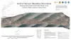
Gulf of Mexico Shoreline Change, Mustang Island and North Padre Island, Texas: Northern Padre Island to Aransas Pass | 2021 | Caudle, T.L., Paine, J.G., Andrews, J.R., Suarez, J.R. | Posters | ||
|
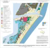
Geo-Environmental map of Northern Mustang Island, Port Aransas quadrangle, Texas Gulf of Mexico Coast | 2006 | Tremblay, T.A., Gibeaut, J.C., Waldinger, R.L., White, W.A., Collins, E.W. | Open-File Map | Bureau of Economic Geology | |
|
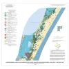
Geo-Environmental map of Southern Mustang Island, Crane Islands NW quadrangle, Texas Gulf of Mexico Coast | 2006 | Tremblay, T.A., Gibeaut, J.C., Waldinger, R.L., White, W.A., Collins, E.W. | Open-File Map | Bureau of Economic Geology | |
|
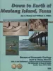
Down to Earth at Mustang Island, Texas | 2002 | Beautifully illustrated by more than 100 photos and diagrams, this nontechnical guide surveys the geologic evolution of Mustang Island and the relationship between physical setting and biologic environments along the Texas coast. |
Raney, J.A., White, W.A. | Down To Earth | Bureau of Economic Geology |
|
Land and water resources, historical changes, and dune criticality: Mustang and North Padre Islands, Texas | 1978 | Barrier islands along the Texas Coastal Zone are part of a complex and dynamic system represented by many distinct yet interrelated environments affected by a variety of resources, natural processes, climatic conditions, and human activities. |
White, W.A., Morton, R.A., Kerr, R.S., Kuenzi, W.D., Brogden, W.B. | Report of Investigations | Bureau of Economic Geology |
|
Shoreline changes on Mustang Island and North Padre Island (Aransas Pass to Yarborough Pass) -- an analysis of historical changes of the Texas Gulf shoreline | 1977 | Historical monitoring along Mustang and north Padre Islands records the nature and magnitude of changes in position of the shoreline and vegetation line and provides insight into the factors affecting those changes. |
Morton, R.A., Pieper, M.J. | Geological Circular | Bureau of Economic Geology |
|
Guide to modern barrier environments of Mustang and North Padre Islands and Jackson (Eocene) barrier/lagoon facies of the south Texas uranium district | 1976 | Combining process and geomorphic description (supplied by studies of modern depositional systems) with the three-dimensional description of sedimentary units and their internal structures (accomplished in the stratigraphic record) produces an integrated facies model that can be applied to the int |
White, W.A., Galloway, W.E. | Research Note |