Land Resources Publications
| Title | Publication Year Sort ascending | Abstract | Author | Series | Publisher | |
|---|---|---|---|---|---|---|
|
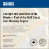
Geology and land use in the western part of the Gulf Coast coal-bearing region | 2002 | Warwick, P.D., Aubourg, C.E., Hook, R.W., SanFilipio, J.R., Barnes, V.E., Morrissey, E.A., Schultz, A.C., Karlsen, A.W. | Miscellaneous Map | Bureau of Economic Geology | |
|
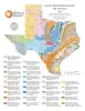
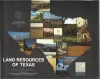
Land-Resource Map of Texas | 1999 | Wermund, E.G. | Thematic Maps | Bureau of Economic Geology | |
|
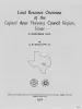
Land resource overview of the Capital Area Planning Council Region, Texas -- a nontechnical guide | 1979 | Bastrop, Blanco, Burnet, Caldwell, Fayette, Hays, Lee, Llano, Travis, and Williamson Counties make up the Capital Area Planning Council (CAPCO) region in Central Texas (fig. 1). The region covers 8,427 square miles (21,826 km2) and includes land of great physical diversity. |
Woodruff, C.M., Jr. | Selected Reports | Bureau of Economic Geology |
|
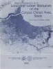
Land and water resources of the Corpus Christi area, Texas | 1978 | Land and water resources have been analyzed in the Corpus Christi area--Aransas, Nueces, Refugio, and San Patricio Counties along the central Texas coast. The city and port of Corpus Christi compose the largest metropolitan center in the area. |
Kier, R.S., White, W.A. | Report of Investigations | Bureau of Economic Geology |
|
Engineering Properties of Land Resource Units in the Corpus Christi Area | 1978 | Land resource units that are defined by their physical properties can be characterized quantitatively using engineering test data. Information about substrate properties in quantitative terms confirms and augments qualitative statements about the physical characteristics of land resource units. |
Kier, R.S., Bell, D.L., Patton, P.C. | Research Note | |
|
Land resources of Texas | 1977 | Texas is endowed with an enormous variety of natural land resources that vary from the humid forest lands of East Texas to the vast desert lands of Trans-Pecos, from the swamps and marshes of the Texas Coastal Zone to the arid plains of the Panhandle, and from the rich farmland of Central Texas t |
Kier, R.S., Garner, L.E., Brown, L.F., Jr., University of Texas at Austin, Bureau of Economic Geology | Selected Reports | Bureau of Economic Geology |
|
Land capability in the Lake Travis vicinity, Texas -- a practical guide for the use of geologic and engineering data | 1975 | The Lake Travis vicinity lies predominantly within a carbonate rock terrane and is the site of ongoing intensive residential development. |
Woodruff, C.M., Jr. | Report of Investigations | Bureau of Economic Geology |
|
Land and Water Resources: Houston-Galveston Area Council | 1975 | The Houston-Galveston Area Council of Governments (HGAC) encompasses over 12,000 square miles of southeast Texas (fig. 1). |
St. Clair, A.E., Proctor, C.V., Jr., Fisher, W.L., Kreitler, C.W., McGowen, J.H. | Selected Reports | Bureau of Economic Geology |