
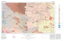
Geologic map that depicts the surface geology of Gaines and Andrews Counties and parts of Yoakum, Terry, Dawson, Martin, Winkler, Ector, and Midland Counties, Texas. The 5-page booklet indicates geologic formations, abbreviations, and ages.
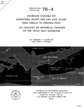
Historical monitoring along Matagorda Island and San Jose Island records the nature and magnitude of changes in position of the shoreline and vegetation line and provides insight into the factors affecting those changes.
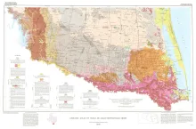
Geologic map that depicts surface geology of Starr, Hidalgo, Willacy, and Cameron Counties and parts of Zapata, Jim Hogg, Brooks, and Kenedy Counties.
The Bureau of Economic Geology has been conducting regional studies of the Frio Formation along the Texas Gulf Coast to evaluate potential geothermal energy from deep, geopressured sandstone reservoirs (Bebout, Dorfman, and Agagu, 1975; Bebout, Agagu, and Dorfman, 1975). The procedures used in this evaluation were reviewed at the Second Geopressured Geothermal Energy Conference held at The University of Texas at Austin and sponsored by the United States Energy Research and Development Administration. The index map (fig. 1) and cross sections (figs.