
Surface mining, with its accompanying dust, noise, truck traffic, and land disruption, generally conflicts with most urban land uses. Urban development, however, is dependent upon the availability of nearby mineral resources for the construction of roads and buildings. As a result of this conflict, many urban areas are now faced with rapidly rising construction costs, partly because of a failure to recognize and use aggregate resources before building over such resources or making them unavailable by zoning.
Aquifers in the Houston-Galveston area are composed principally of fluvial-deltaic sediments. The Alta Loma Sand is a complexly faulted, high-sand-percent unit that represents a seaward progression of fluvial, delta-plain, and delta-front facies. The Beaumont Formation, overlying the Alta Loma Sand, is a high-mud-percent unit that represents a coastal progression of delta-plain to delta-front facies. Four arbitrarily defined intervals from land surface to 2000 ft indicate superposition of dip-oriented and strike-oriented high-sand-percent trends.
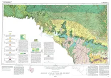
Geologic map that depicts surface geology of Kinney County and parts of Terrell, Val Verde, Edwards, Real, Uvalde, and Maverick Counties, Texas.
In order to better understand the control exerted by fractures on the recharge and production zones of limestone aquifers, the authors delineated surficial fracture zones in the southern Edwards Plateau, Texas. Lineations were marked on nearly 200 mosaics scale of 1:24,000. Approximately 400 fracture zones were identified on each mosaic.