Specialized maps and charts covering a wide variety of topics and areas including historic Texas geological maps, Enchanted Rock, Big Bend National Park, Lake Travis, and more.
Miscellaneous Maps, Charts & Sections
-

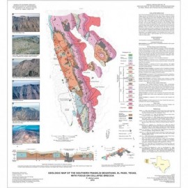
Southern Franklin Mountains, El Paso,... Southern Franklin Mountains, El Paso,...
$16.00Geologic Map of the Southern Franklin Mountains, El Paso, Texas, with Focus on Collapse Breccias, by F. J. Lucia. 2011. Oversized color map, scale 1:100,000. Includes color photos. Print Version.For a downloadable, digital version: MM0049D. Geologic Map of the Southern Franklin...
 In Stock
 -

Geologic Map of Mariscal Mountain, Big... Geologic Map of Mariscal Mountain, Big...
$10.00Geologic Map of Mariscal Mountain, Big Bend National Park, Texas, by P. W. Dickerson, W. R. Muehlberger, and E. W. Collins. Oversize color map, scale 1:24,000, 2010. Digital Version.For a print version: MM0048. Geologic Map of Mariscal Mountain,...
In Stock -

Geologic Map of Mariscal Mountain, Big... Geologic Map of Mariscal Mountain, Big...
$18.00Geologic Map of Mariscal Mountain, Big Bend National Park, Texas, by P. W. Dickerson, W. R. Muehlberger, and E. W. Collins. Oversize color map, scale 1:24,000, 2010. Print Version.For a downloadable, digital version: MM0048D. Geologic Map of Mariscal Mountain,...
In Stock -

Southeast Part of the Austin, Texas, 30 x... Southeast Part of the Austin, Texas, 30 x...
$10.00Geologic Map of the Southeast Part of the Austin, Texas, 30 x 60 Minute Quadrangle: Central Texas Population Corridor Encompassing Bastrop and Smithville, by E. W. Collins. Oversize color map, scale 1:100,000, 2008. Digital Version.For a print version: MM0047. Geologic Map of the Southeast Part of...
In Stock -

Southeast Part of the Austin, Texas, 30 x... Southeast Part of the Austin, Texas, 30 x...
$16.00Geologic Map of the Southeast Part of the Austin, Texas, 30 x 60 Minute Quadrangle: Central Texas Population Corridor Encompassing Bastrop and Smithville, by E. W. Collins. Oversize color map, scale 1:100,000, 2008. Print Version.For a downloadable, digital version: MM0047D. Geologic Map of the Southeast Part of...
In Stock -

Glenn Spring Quadrangle, Texas. Digital... Glenn Spring Quadrangle, Texas. Digital...
$10.00Geologic Map of the Glenn Spring Quadrangle, Big Bend National Park, Texas, by E. W. Collins, W. R. Muehlberger, and P. W. Dickerson. Oversize, 2-sheet color map, scale 1:24,000, 2008. Digital Version.For a print version: MM0046. Geologic Map of the Glenn Spring...
In Stock -

Glenn Spring Quadrangle, Texas Glenn Spring Quadrangle, Texas
$16.00Geologic Map of the Glenn Spring Quadrangle, Big Bend National Park, Texas, by E. W. Collins, W. R. Muehlberger, and P. W. Dickerson. Oversize, 2-sheet color map, scale 1:24,000, 2008. Print Version.For a downloadable, digital version: MM0046D. Geologic Map of the Glenn Spring...
In Stock -

Del Rio, Texas, Area. Digital Download Del Rio, Texas, Area. Digital Download
$10.00Geologic Map of the Del Rio, Texas, Area, by E. W. Collins. Oversize color map, scale 1:100,000, 2007. MM0045D, $12.00. - Digital Version.For a print version: MM0045. Geologic Map of the Del Rio, Texas,...
In Stock -

Del Rio, Texas, Area Del Rio, Texas, Area
$16.00Geologic Map of the Del Rio, Texas, Area, by E. W. Collins. Oversize color map, scale 1:100,000, 2007. Print Version.For a downloadable, digital version: MM0045D. Geologic Map of the Del Rio, Texas,...
In Stock -

Oil and Gas Map of Texas - Postcard.... Oil and Gas Map of Texas - Postcard....
$0.00Oil and Gas Map of Texas. Color postcard, 4 x 6 inches, issued in April 2006. Digital Version.For a print version: MM0044. Oil and Gas Map of Texas. Color...
In Stock -

Oil and Gas Map of Texas - Postcard Oil and Gas Map of Texas - Postcard
$0.25Oil and Gas Map of Texas. Color postcard, 4 x 6 inches, printed on card stock, 2006. The digital file includes text for the front (map) and back (address) sides. Print Version.For a downloadable, digital version: MM0044D. Oil and Gas Map of Texas. Color...
In Stock -

West Half of the Taylor, Texas, 30 x 60... West Half of the Taylor, Texas, 30 x 60...
$10.00Geologic Map of the West Half of the Taylor, Texas, 30 x 60 Minute Quadrangle: Central Texas Urban Corridor Encompassing Round Rock, Georgetown, Salado, Briggs, Liberty Hill, and Leander, by E. W. Collins. Oversize color map, scale 1:100,000 and 16-p. text, 2005. Digital Version.For a print version: MM0043. Geologic Map of the West Half of the...
In Stock