Miscellaneous Maps, Charts & Sections
-
Books & Reports
- Reports of Investigations
- Guidebooks
- Udden Series
- Geological Circulars
- Down To Earth
- Atlases of Major Oil and Gas Reservoirs
- Texas Memorial Museum Publications
- Environmental Geologic Atlas of the Texas Coastal Zone
- Mineral Resource Circulars
- Other Reports
- Seminars and Workshops
- Handbooks
- Submerged Lands of Texas
- Symposia
- Annual Reports
- Open File Reports
-
Maps & Cross Sections
- Thematic Maps
- Miscellaneous Maps, Charts & Sections
- Geologic Atlas of Texas
- STATEMAP Project Maps
- Geologic Quadrangle Maps
- Cross Sections
- Highway Geology Map
- Energy and Mineral Resource Maps
- Shoreline Change and Other Posters
- Wilcox Group, East Texas, Geological / Hydrological Folios
- Bouguer Gravity Atlas of Texas
- River Basin Regional Studies
- Featured Maps
- Posters
- Teachers & the Public
-
Geological Society Publications
- Gulf Coast Association of Geological Societies
- Alabama Geological Society
- Austin Geological Society
- Corpus Christi Geological Society
- Houston Geological Society
- Lafayette Geological Society
- Mississippi Geological Society
- New Orleans Geological Society
- South Texas Geological Society
- GCS SEPM Publications
- Historic BEG & UT Series


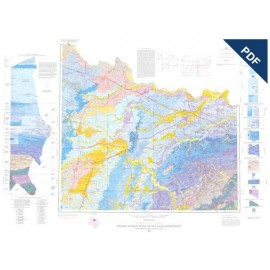
MM0045D. Geologic Map of the Del Rio, Texas, Area, by E. W. Collins. Oversize color map, scale 1:100,000, 2007. MM0045D, $12.00. - Downloadable PDF.
To purchase this publication in paper format, please order MM0045.
About This Map
Constructed through digital compilation of nine 1:24,000-scale open-file geologic maps, this map is designed to be used by laypeople and professionals for geologic information about land and resource use and management. It includes Del Rio, a border town on the Rio Grande, six aquifer outcrop belts, and the Amistad National Recreation Area. Support for this mapping was partly provided by the STATEMAP program of the U.S. Geological Survey and by staff at the Texas Water Development Board.
Keywords: maps, geologic maps, Del Rio area, Amistad National Recreation Area, land resources, Texas
Citation
Collins, E. W., 2007, Geologic Map of the Del Rio, Texas, Area: The University of Texas at Austin, Bureau of Economic Geology, Miscellaneous Map No. 45, scale 1:100,000.